
Region
Highlights
Routes
8 climbs • 14.2 km • 4,590 m gain • 5 hr 40 min • Class 2
3 climbs • 15.9 km • 4,887 m gain • 7 hr 31 min
1 climb • 15.9 km • 4,887 m gain • 8 hr 27 min
1 climb • 17.5 km • 5,258 m gain • 10 hr 57 min
Latest climbs
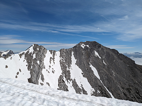
"A very enjoyable ascent of Phillips Peak, "difficult" scramble near the top, a few "difficult" moves which felt awkward on the way down followed by the knife edge ridge. Mt. Tecumseh is easier moderate (Class 2 terrain). We could not traverse the steep ledge between the two summits since it was filled with snow and didn't look safe. Instead, we went down additional 100 vertical meters where the slope was dry. Tecumseh is complete opposite of Phillips - it's a boring slog on tedious rubble. The views are better than from Phillips though. Snow made the descent into the bowl easier. It should suck later in the season when the snow is gone. The rest of the route follows creek and is tedious (except for a short slot canyon). As much I enjoyed Phillips I didn't like Tecumseh." — Taras • Jun 9, 2024

"we went up to Phillipps peak's false summit to measure the position of a border marker placed in 1922, with a high-precision GPS unit/ While in the neighbourhood, we climbed Phillipps Peak, came down the ridge to find a narrow ramp traverse in to the bowl below Mt Tecumseh, which we then climbed. We finished by coming out via the canyon normal route to Tecumseh. A long day, with 3 spot that I would consider difficult scrambling." — apfelstrudel • Sep 19, 2020

"Bike and Hike. Climbed South ridge of phillips peak which had some moderate scrambling along it till the summit ridge which was exposed but solid enough. Descended to the scree ramp on the SE ridge and gained the normal ascent route for Tecumseh. " — ken_hercules • Jul 8, 2020
"Stephan and I made the long drive down to the Crowsnest and went via Bragg Creek and the 22. Such a nice drive. I would have liked to start about an hour earlier, but at least we didn't anticipate a long scramble. From Highway 3 we drove along the forestry service road from the weigh station just across on the BC side and saved ourselves about 200m elevation and some distance according to the book; you would want a 4x4 for this road. There was construction at the pass and some people at the lake, but we had the entire mountain to ourselves. Love love love this! We parked near Philips Lake/Pass and went up the drainage for a bit before taking the left bank, then crossing back to the right side again near the big boulders. We followed Kane's description and Bert's .gpx track as required. Stephan hated it as usual and threw his poles in only one tantrum today.. but he did enjoy the final ridge, which is fun. Views were spectacular!!!! I love how Crownest just rises out of the sea of dark conifers from the valley. I liked this one a lot plus it was hot, sunny and clear. Stephan wanted a few breaks here and there, so we took the full 6 hours from the pass. You can absolutel..." — leigh-annewebster • Jul 15, 2018

"We started up to the (climber's) right of the drainage, as the trail was way better than working the bottom of the drainage, and as a result we made excellent time on the lower part. Up higher we didn't go into the big opening on the left right away, but skirted around the bottom of the steep slopes before finally ascending to the ridge and into the clouds. The ridge itself was quite wide and the exposure was not too bad either. Where the ridge was sketchier, one could just drop down and continue on.
We beat the rain but ended up doing the upper third of this hike in the clouds." — BertB • Aug 15, 2015

"Technically I didn't summit this one as there was a lightning storm and I didn't think being on the very top was that smart. I did however get to within 30 meters of it so...
We followed the creek that comes out at the bottom of the drainage on the Southwest corner of the mountain. At the top of the narrow part of the creek, it opens up into a large bowl. We followed the drainage up some more, trending to the left. We were able to pick up a faint trail heading up the talus slope to a rock band just before the summit. A scramble through the rock band put us about 350 meters from the summit. The lightning was closing in on us and my buddy decided to stop. I, being either braver or stupider, made a run for it and tried to make the summit before the weather closed in on us. I too was deterred just a few meters from the summit. I did get quite an awesome shot of Crowsnest and Seven Sisters under a very ominous cloud.
We came down the same way as going up getting caught in a hail storm and having to take shelter under the slope of a large boulder." — yantski • Aug 8, 2009

"Biked into philips pass via the bc. side and up the drinage to the north,using the westerly side to stay high saved time,then west on arrival to the side gully left on a trail on the laft side and curved around to hit the ridge by going right to the north thereby hitting the ridge just west of the summit,go right to the east to hit the summit.awesome day out!trr the rock rambler!" — larry-derksen • Jun 18, 2008
Photos
Awards
Challenges
About peakery awards
Log climbs on peakery to earn awards:
Peak Badges: Earn a special badge for each unique peak you summit. See all of your badges on your Badges page.

First Ascent Award: Only 1 available per peak. Goes to the first peakery member to log a successful summit of a peak. Snag this award and the peak will forever bear your name.

King of the Mountain Award: Only 1 available per peak. Summit a peak more times than any other member. Beware: this award can be lost!

Summit Steward: Summit a peak at least 5 times to become one of its Summit Stewards. As Steward of a peak, you’re encouraged to keep that peak’s info up-to-date on peakery and spread goodwill on your future climbs up the peak.