
Region
Highlights
Routes
3 climbs • 2.2 mi • 1,455 ft gain • 2 hr 18 min
2 climbs • 3.0 mi • 1,512 ft gain • 3 hr 37 min
1 climb • 4.2 mi • 1,908 ft gain • 4 hr 13 min
Latest climbs
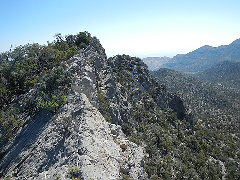
"The Potosi Pass road is currently in good condition, suitable for a 2WD vehicle with 6" clearance, to the 2WD parking on the west side of the road at 35.97997, -115.53326, BUT NO FARTHER. IMMEDIATELY after this point, there is gully in the road, which requires a more substantial vehicle, and there are better parking spots 100m farther down the road. As for the hike, the south route I took UP has creepy class 3 for about 100' vertical; there are no hard moves, but the route is on steep, crumbly rock with thorny bushes and inconvenient talus. The route I took down has a short section of thin rocky edge, but there is always a class 2 way, with a few bits of eye-opening exposure. After dropping through the cliffs, it is mainly a walk, looking for the best path through the bushes. My 5x; in 2005 there was no register." — hwstock • May 20, 2024
"Conditions: the road has a 3' smooth gully just SW of where we parked. We actually pulled right (W) off the bad section of road, and had to scrape a few bushes to be totally safe. If you want to descend farther on this road by car, either have a wide-high 4x4 to straddle the sides of the gully, or break down the sides with a huge pry bar, or just be a really good driver! We basically followed Jerry Thomas' track. I guess I prefer my original route; though the direct route has one sketchy section, it has less talus." — hwstock • Oct 8, 2023
"2nd time up, I explored the north ridge down. Very frictional on ridge, some steep talus to navigate in exit chute. A register had appeared, no surprise as CP included it in his 2008 guide." — hwstock • Jun 1, 2014
Photos
Awards
About peakery awards
Log climbs on peakery to earn awards:
Peak Badges: Earn a special badge for each unique peak you summit. See all of your badges on your Badges page.

First Ascent Award: Only 1 available per peak. Goes to the first peakery member to log a successful summit of a peak. Snag this award and the peak will forever bear your name.

King of the Mountain Award: Only 1 available per peak. Summit a peak more times than any other member. Beware: this award can be lost!

Summit Steward: Summit a peak at least 5 times to become one of its Summit Stewards. As Steward of a peak, you’re encouraged to keep that peak’s info up-to-date on peakery and spread goodwill on your future climbs up the peak.