
Region
Highlights
Routes
13 climbs • 6.3 km • 3,059 m gain • 5 hr 16 min
2 climbs • 17.0 km • 3,968 m gain • 8 hr 29 min
Latest climbs
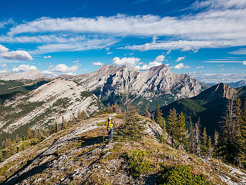
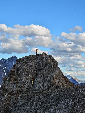
"Opal Ridge Traverse (North to South), August 20, 2024 (Kane Difficult Scramble). Had a great time on this scramble yesterday. A large amount of enjoyable ridge scrambling in the alpine. One of the better scrambles I've done. Some interesting route finding, great views, fun scrambling on mostly good rock, with nothing too tedious. The route from the road up to the north peak is a steep grunt but doesn't last too long before it eases up. Then the whole ridge is enjoyable save for the one section where you must avoid "a wall" by losing ~150m. I did go up it directly, it's mid 5th climbing (5.6-5.7?) and therefore is recommended to go around it if you don't have ropes (bolted station on top and piton on the pitch).
We had helmets but didn't feel the need to put them on, did not have any rockfall issues.
We stashed bikes near the gas station for a quick mostly downhill return to the cars at Opal Day use parking. 19km 1800m total gain, 8.5 hours. 5 stars!" — jakefinnan • Aug 20, 2024

"Solo trip. I did just Opal north 12 years ago but this time did traverse. Crux was getting off north peak , this section was difficult and exposed in one spot. Other than that traverse was pleasant, lots of hands on scrambling, short ones, slight exposure in some spots but never really hard. Visited several high points. It was pretty bad smoke in the morning, got better in the afternoon." — PawelG • Jul 15, 2023
"After work scramble. Plan was to do needle spoon. Galatea area closed for bear activity, blocking a north ridge attempt. River was too high to cross in the afternoon and recent rain for South ridge approach. Time to climb the other side of the road" — ken_hercules • Jun 25, 2018

"Traversed ridge from North to South. Great conditions, albeit a bit warm. We stayed high on the ridge for the most part ducking low only a few times. Someone has drilled gym-style climbing holds into the crux, which also has two relatively new looking pitons on the way up and a new looking bolt anchor with rap rings at the top. " — BobbyG • May 28, 2017

"The first slopes to gain the ridge are dry. There is still snow lingering around on the ridge. There was snow in the gully. I understand the summit is the one rounded over peak, and not the next peak a bit further down. I climbed up the exposed section to get to the summit of the next peak further down anyways." — BertB • Apr 24, 2015

"Solo trip. 2 hrs up. 1.5 hrs down. Didn't see anyone. Not sure about the start of the trail. Followed a blue flagging tape ("Altalink") just south of the Rock Creek Bridge/Eau Claire Campground turnoff (closed). Trail appeared new and went up to a new power line pole. Eventually scrambled up and found a trail. Came down almost the same except cut south near the end and then followed the cut line trail back north to where I started. - See more at: http://peakery.com/opal-ridge-canada/#sthash.JhJgId5O.dpuf" — alexjoseph • Sep 16, 2012
Photos
Awards
Challenges
About peakery awards
Log climbs on peakery to earn awards:
Peak Badges: Earn a special badge for each unique peak you summit. See all of your badges on your Badges page.

First Ascent Award: Only 1 available per peak. Goes to the first peakery member to log a successful summit of a peak. Snag this award and the peak will forever bear your name.

King of the Mountain Award: Only 1 available per peak. Summit a peak more times than any other member. Beware: this award can be lost!

Summit Steward: Summit a peak at least 5 times to become one of its Summit Stewards. As Steward of a peak, you’re encouraged to keep that peak’s info up-to-date on peakery and spread goodwill on your future climbs up the peak.