Highlights
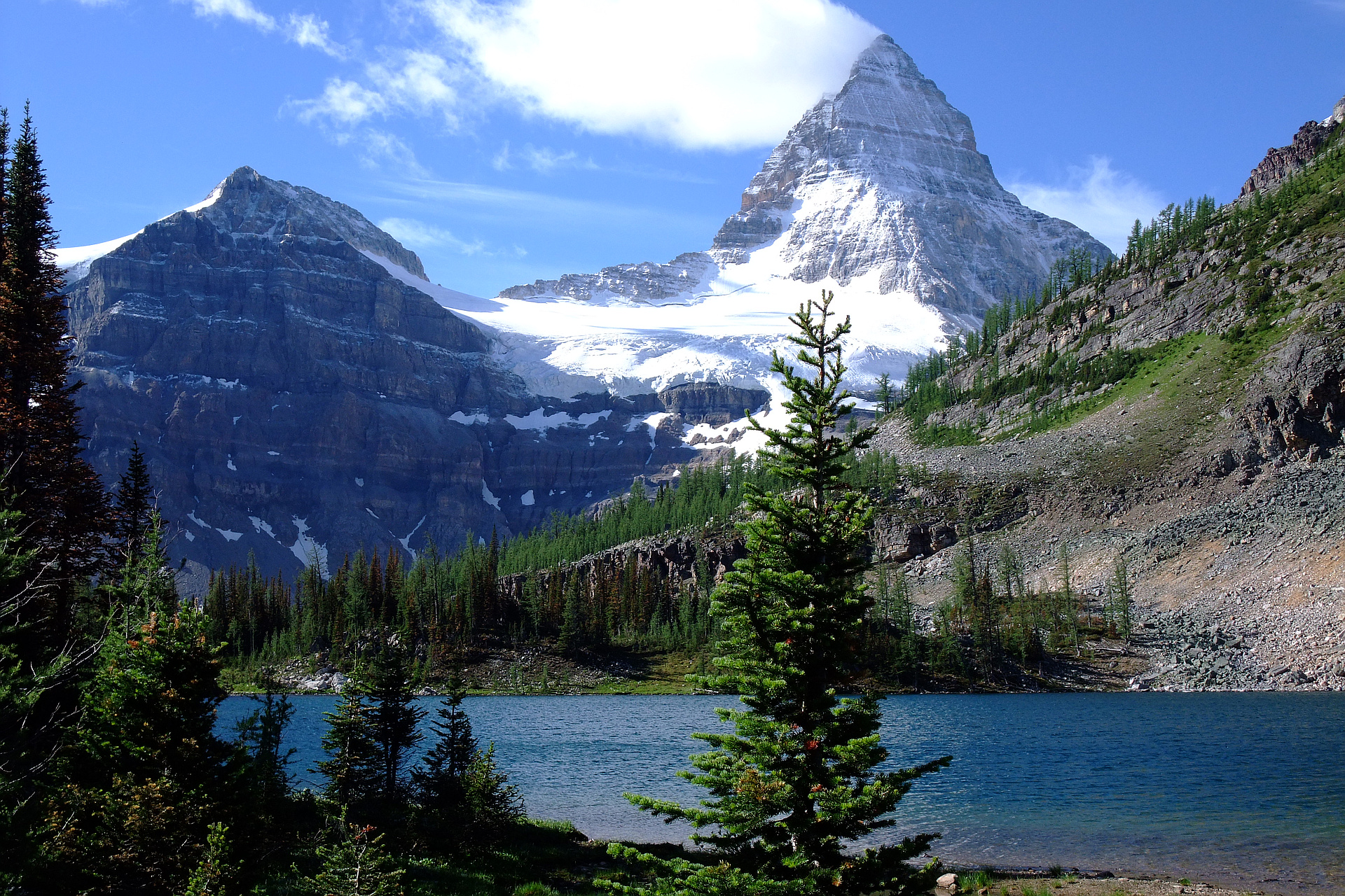
- Mount Assiniboine lies on the Great Divide, on the British Columbia/Alberta border in Canada.
- Highest peak in the Southern Continental Ranges of the Canadian Rockies.
- Due to Assiniboine's pyramidal shape, it has been unofficially named the "Matterhorn" of North America.
- Mount Assiniboine rises nearly 1,525 m (5,003 ft) above Lake Magog.
- Mount Assiniboine lies on the border between Mount Assiniboine Provincial Park, in British Columbia, and Banff National Park, in Alberta.
- The park does not have any roads and can only be reached by a 6 hour hike 27 km (17 mi). The usual approach is via Bryant Creek.
- There are no scrambling routes up Mount Assiniboine.
- The easiest mountaineering routes are the North Ridge and North Face rated Class 5.5 which are reached from the Hind Hut.
Routes
/-115.651376180717,50.8697880897028,11,0.00,0.00/320x240@2x?access_token=pk.eyJ1IjoicGVha2VyeSIsImEiOiJjampra3Z0bnAxeTVnM3FteHlybHY3b2p1In0.7a5dEa5-995VUv8ceHHNmw)
10 summits • 26.2 km • 2,093 m gain • 11 hr 44 min
2 summits • 31.4 km • 2,544 m gain • 21 hr 24 min
1 summit • 30.2 km • 2,728 m gain • 13 hr 22 min
1 summit • 35.0 km • 3,331 m gain • 20 hr 57 min
Latest summits

"Route: North Ridge from Hind Hut.
Conditions: Ideal weather; dry route throughout.
Timing: 6 hours to summit, 1/2 hour on summit, 5 hours return to hut.
Approach: Helicopter to Assiniboine Lodge, then Gmoser Highway to Hind Hut. Gmoser Ledges are exposed and required careful scrambling. 3 hours from lodge to hut. Fellow climbers from BC side noted that the Sturdee Glacier was dry with large crevasses. They recommended taking the climber's left of the glacier for the best route.
Scrambling: Fun and sustained. Relying on cairns, footprints, crampon marks, and trails made route-finding straightforward. The Red Band section had great rock quality.
Roping Up: Chelsea and I roped up when ridge steepened below the Gray Band, beginning at the lower rappel station. Mike and Cam free soloed to summit. We took 3 pitches to reach the Gray Band crux.
Gray Band Crux: Managed using cams to protect a few exposed moves around an awkward feature. Belayed Chelsea to a bolted rappel station, then completed a final pitch to the upper ridge.
Summit: No snow made the upper ridge easy; enjoyed breathtaking views.
Descent: Utilized 6 rappels with some downclimbing between a few of them..." — ivo • Aug 19, 2023

"Ascended via BC approach, Soloed NE Ridge in perfect conditions and made 4 rappels on the way down, Incredible views and had a nice rain shower cool us off on the way out. Wedgwood and Strom are great bonus scree bashes." — ken_hercules • Jul 3, 2021

"Assiniboine attempt #2.... last year I got hit by lightning high on the peak so surely this would be better? While the weather was better the conditions were not. The heavy rain/snow from Saturday morning coated the route in verglas. We turned around at the red band after fighting with ice and snow and getting off route trying to avoid the worst of it. Annoying since everyone all week enjoyed perfect conditions! We then got charged by a grizzly bear when we returned to camp at Assiniboine Lake.... what does attempt 3 have in store for me? Perfect weather and conditions please? " — jakefinnan • Aug 23, 2020

"Mostly clear skies to begin and we made excellent time to the grey band. We turned around 150m below the summit just as I did last week. We made it above the crux pitch when a thunderstorm rolled in. Before we could finish setting up the rappel we were "buzzing". I got struck by lightning minutes later while in the fetal position on the N ridge at 3450m waiting for it to pass. I am uninjured and none of my gear burned. We sat for 20 minutes before it was reasonable enough to descend. Tons of graupel and snow accumulated further complicating our descent. It was a slow go with crampons still on well below the red band when another storm struck and we had to hunker down and wait for it to pass once more. Some very close lightning striking between climbing parties. 11 attempts, no summits, 1 hit by lightning, 1 hit by a large rock, and a 10m nearly fatal fall with a lost ice axe, everyone made it back safely somehow in the end. Craziest morning of my entire life. Maybe I should just go camping next weekend....." — jakefinnan • Aug 31, 2019

"Ascended NE ridge, descended South face. Great conditions on the NE ridge, lots of tat on boulders - even through the scrambling sections. Some permanent bolted stations above the exposed fifth class sections. Nasty choss on the South face - bailed on Mt Lunette after some significant rock fall. One of the sketchiest descents I have ever done, we were forced into several gullies with massive overheard rockfall potential." — BobbyG • Jul 29, 2017

"Climbed the north ridge on Mt. Assiniboine. Still a lot of snow on the mountain from the previous week but good weather on the day of the climb. Crampons on for 5/6 of the climb. Good snow on the way up but balling up the crampons on the way down." — MichaelDyck • Sep 22, 2014

"We were rock climbers then and this was taking our mountain aspirations up a notch. We biked/walked in from Mt Shark but the weather would turn us around when we couldn't find the approach up Gmoser Highway Ledge Route which we couldn't find and then descended to one of the most intense hail-thunderstorms I've experienced in a bivy bag. Bailed and hitched (2 rides) home to Calgary to hang with family on August Long Weekend Monday." — alexjoseph • Aug 5, 2001
Awards
Challenges
About peakery awards
Log successful summits on peakery to earn awards:
Peak Badges: Earn a special badge for each unique peak you summit. See all of your badges on your Badges page.

First Ascent Award: Only 1 available per peak. Goes to the first peakery member to log a successful summit of a peak. Snag this award and the peak will forever bear your name.

King of the Mountain Award: Only 1 available per peak. Summit a peak more times than any other member. Beware: this award can be lost!

Summit Steward: Summit a peak at least 5 times to become one of its Summit Stewards. As Steward of a peak, you’re encouraged to keep that peak’s info up-to-date on peakery and spread goodwill on your future climbs up the peak.