
Region
Most climbed route
Highlights
Routes
2 climbs • 24.7 km • 6,126 m gain • 8 hr 37 min
1 climb • 14.6 km • 3,304 m gain • 6 hr 23 min
1 climb • 21.1 km • 5,505 m gain • 8 hr 13 min
1 climb • 23.5 km • 1,463 m gain • 12 hr 42 min • Class 2
Latest climbs
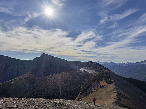
"I didn't read Nugara's book carefully enough and was not aware of existence of two routes up Mt. Gladstone, so I went up a hiking route, which is pretty much a walk-up. Several sources describe the scrambling route as "dull" and "uneventful calf-burner", so I probably didn't lose much. In contrast, the hiking route goes over pleasant Waterton-style shale. Summer conditions on the hiking route.
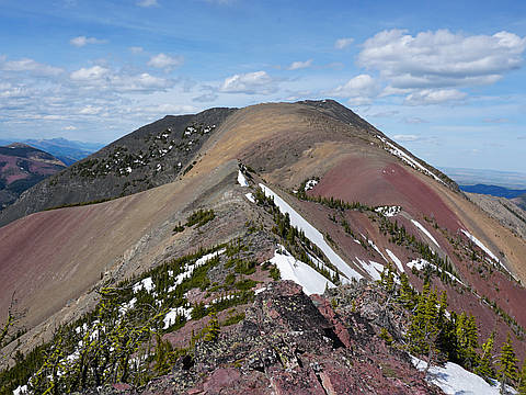
Traverse to "Larry Mountain" and "Frankie Peak" was pretty much a hike with lots of rock-hopping. Only brief "moderate" scrambling near the top of Frankie. Traverse to North Castle was also 99.99% walking with a bit of scrambling near the top. I descended into Mill Creek valley from North Castle, which saved some time.
Snow patches there and here, but the snow was firm enough to support my weight and soft enough to allow step plunging, so my ice-axe and crampons stayed in the backpack.
I found an ungodly number of ticks crawling all over my body. If you are worried about ticks, I don't recommend ascending Mt. Gladstone in May-June via Mill Creek Valley." — Taras • May 24, 2026

"I camped at the base (south of the mountain), then climbed Gladstone and North Castle in the cool of the morning. It didn't stay cold, and started developing heat cramps on the way out. " — AaronKauffman48 • Jul 8, 2024
"This loop took in a number of official & unofficial peaks in Castle Provincial Park. The South Castle access road was dry but a little rough in places, with some potholes big enough to swallow a car.
The trail is excellent up to Whistler Mountain and the side-trip over to Table Top Peak. From there we followed the ridge back along to Frankie Peak & Larry Mountain, where there were a few sections of moderate scrambling. We descended the ridge a bit further and then dropped through a short forest section into the bowl south-east of Mount Gladstone. From there was a straightforward stroll up to the Gladstone summit, the highpoint of the day. We headed down to the forested bump known as North Castle, where some short rock bands provided the most interesting scrambling of the day. The descent back down the ridge to the road crossed through light forest and grassy slopes, until the last kilometer which was frequently a logstacle course." — geoffhardy • Oct 17, 2021

"22.8km with 1885m gain in 8:15hrs return. Supposed to be a CSMC trip but was left alone.
Not bad time for the 4th day in a row.
Was very windy in the morning and afternoon; rain was forecasted for the evening but clouds started to roll in around 1pm. Got a drizzle during descend off North Castle. " — alexp • Jul 1, 2019

"Escaped the snow in the Central Rockies with a trip to Castle/Waterton. We chose Gladstone for our first day.
The route is in really good condition. We crossed one supportive (and inconsequential) patch of snow, but it was dry otherwise. Mill Creek was running swift, mid-calf depth. The rocks in the creekbed were a bit slick, but it was an easy, though very cold, barefoot crossing.
From a macro perspective, route finding is easy, but there are a few challenges on a smaller scale. First, we went too far south on Mill Creek. We diverted from the ATV trail (due to a downed tree), and caught a horse trail which led us to a crossing a bit far upstream. Fortunately, we were able to cross on a log jam (easy), but this was followed by some bushwhacking (deadfalls) to get back on track.
We found the correct hiking trail, but it is badly overgrown. The ground is clear (and has good footing), but you need to bust through veg from waist up. In need of a good machete. This improves as you gain elevation.
The ascent drainage was straightforward. Just follow the easiest line. It is all very steep hiking, and a bit of a calf burner.
By the time we reached the black rockbands, we..." — mike_rogers81 • Jun 10, 2017
Photos
Awards
About peakery awards
Log climbs on peakery to earn awards:
Peak Badges: Earn a special badge for each unique peak you summit. See all of your badges on your Badges page.

First Ascent Award: Only 1 available per peak. Goes to the first peakery member to log a successful summit of a peak. Snag this award and the peak will forever bear your name.

King of the Mountain Award: Only 1 available per peak. Summit a peak more times than any other member. Beware: this award can be lost!

Summit Steward: Summit a peak at least 5 times to become one of its Summit Stewards. As Steward of a peak, you’re encouraged to keep that peak’s info up-to-date on peakery and spread goodwill on your future climbs up the peak.