
Region
Highlights
Routes
2 climbs • 20.3 km • 4,612 m gain • 10 hr 48 min
1 climb • 25.8 km • 3,010 m gain • 10 hr 34 min
1 climb • 3.7 km • 1,125 m gain • 2 hr 49 min
1 climb • 41.2 km • 7,470 m gain • 51 hr 11 min
1 climb • 42.7 km • 4,353 m gain • 12 hr 27 min
Latest climbs
"This was a big day out into an area that I had wanted to explore for quite a while. The bike approach from Mt Shark was excellent, although I would suggest leaving bikes at the last bridge, rather than pushing them uphill to the "No bikes" sign. We hiked the excellent trail to scenic Owl Lake and then the occasionally overgrown trail up to Marvel Pass, getting completely soaked from walking past all the wet foliage. From there, its a short hike up and over "Little Marvel" followed by a somewhat tedious sidehill around to the base of the summit block and some moderate scrambling to the summit. The air was the clearest it has been all summer and the summit views of the Assiniboine area were fantastic. On the way down we dropped into drainage to avoid returning all the way back to Marvel Pass.
13km bike, 34km hike, 12:20 hours, 1800m elevation gain" — geoffhardy • Aug 25, 2021

"Marvel Peak, bike+scramble
44.25km with 1,900m gain in 11:30hrs
scramble involved: lots of boring hiking, some good and difficult scramble, sporadic trail running.
bike - 12.5km return
It's a shame that biking isn't allowed on Bryant Creek trail; for the first 5k it is actually a road in perfect condition. If to ask the Parks, they may allow it; though I guess a chance of that is lower than of winning a lottery :D
Saw Jake & Vern's reports from the BC side. After doing some investigation, got the following numbers:
Vern's TR - 23km with 1,600m gain; drive to a trailhead from Calgary - 280km
from Mt Shark parking - 6km x 2 on bike, ~30km on foot; drive from Calgary 140 or 170km via Canmore or Hwy 40 correspondingly.
Decided that I'd better spend some time on the bike vs driving twice as much.
In addition to that, was really interested to see if the North ridge is going. Which worked out really well: nice easy to moderate scramble to the first high point on the ridge. And difficult exposed at couple sections - to the main summit.
The way out: as it was my first time in the area, was interested to do a loop. In retrospective: the views from the lake are bad, an exi..." — alexp • Oct 3, 2020

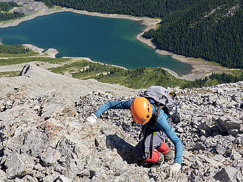
"Marvel Peak - July 18 2020. This one certainly doesn't see much traffic, the only information online is a trip report from 1992 of a less than ideal route! We did hours of research and combing through various photos taken from places nearby and combined that with a brief text description of a "4th class" route from 1945, which turned out to be the way! I can happily report it is no more than moderate scrambling (3rd class). The crux is honestly the loose side-hilling, it's much more sketchy than the scrambling on the summit ridge. We started from Baymag mines area off settlers road, hiked through a nice (but overgrown) trail up to Aurora Lake which is an amazing place. From there it is easy off trail up to the summit of Little Marvel (Penny's Peak) which is an easy scramble. You then drop down and lose about 200m on scree. From the Marvel/ Little Marvel col you head straight towards the LH side of the cliff face, trying to avoid gaining too much elevation while side-hilling on loose garbage. Once you get to the face, it's a loose hike up a scree ramp to the summit ridge, where some pleasant moderate scrambling takes you to the summit. The views on this outing are all time. I highly..." — jakefinnan • Jul 18, 2020
Photos
Awards
About peakery awards
Log climbs on peakery to earn awards:
Peak Badges: Earn a special badge for each unique peak you summit. See all of your badges on your Badges page.

First Ascent Award: Only 1 available per peak. Goes to the first peakery member to log a successful summit of a peak. Snag this award and the peak will forever bear your name.

King of the Mountain Award: Only 1 available per peak. Summit a peak more times than any other member. Beware: this award can be lost!

Summit Steward: Summit a peak at least 5 times to become one of its Summit Stewards. As Steward of a peak, you’re encouraged to keep that peak’s info up-to-date on peakery and spread goodwill on your future climbs up the peak.