Region
Highlights
Routes
/-114.937185399511,36.1486817509425,11,0.00,0.00/320x240@2x?access_token=pk.eyJ1IjoicGVha2VyeSIsImEiOiJjampra3Z0bnAxeTVnM3FteHlybHY3b2p1In0.7a5dEa5-995VUv8ceHHNmw)
7 summits • 2.4 mi • 1,171 ft gain • 2 hr 52 min
2 summits • 1.4 mi • 1,057 ft gain • 2 hr 15 min
2 summits • 5.3 mi • 1,260 ft gain • 6 hr 1 min
1 summit • 13.0 mi • 1,730 ft gain • 6 hr 18 min
Latest summits

"Peakery deleted my GPS on this one 😑 so I just recorded the beginning of the dirt road I came in on. Any car should be able to get within about a half mile of the butte. More fun that I thought but it’s worth going up just to read the old registers from 2002-2005 before the age of social media where people just wrote their unhinged thoughts in a register instead of on Facebook" — joshortman • Jan 11, 2023

"4.6.2021~Lava Butte & Lava Ridge HP. 5.2 miles, 1,500’ gain, 2:50hrs including :20 min summit break. My youngest child Summer returned to school full time today (yay!) so I needed a workout close by so I chose a new (to me) route up to Lava Butte. It was a warm day and an 11am start with a high temp of 85 made for a hot trek in the open desert. I caught a refreshing breeze here and there that made it tolerable. I was on high alert for rattlesnakes but luckily never encountered any. I only saw one cactus blossom the whole way and the skeletal remains of last years wildflowers. The 2020 drought has made for a virtually nonexistent super-bloom in our area. This is a really pretty route with superb views of all the amazing peaks & ridge traverse accomplishments I did in Rainbow Gardens, LLV, Frenchman’s, the AFB & Lake Mead area this past Winter. Glad I could get a good workout in before my 2nd Moderna vaccine shot since my side effects last time were tiredness & fatigue for a few weeks." — paula.raimondi • Apr 6, 2021

"A beautiful day to hike. 55 degrees, 2ish pm. I haven't peakbagged in awhile and this one is a) an extinct volcano and b) short so I figured I'd put in my peakbagging hat and go for it.
As others have said, it's steep, but in a really fun way. There is a loose "trail" that kinda zig zags out of existence, but it's a fairly straightforward mountain to climb, so even if you lose track of it, as long are you are going upish, you're fine. Used the regular summit GPS trail here and it worked like a charm. Probably one of the best views of the general Vegas/Mead area I've seen yet. 10/10 would do again!
Rough, but short. Loved it. " — alexehagen • Jan 3, 2021

"I had seen Tan Ridge on another site & wanted to go check it out. I had no plans to climb Lava Butte, but it was right there, so... I went up in the middle of Tan Ridge right off the Lava Butte Road & first headed out to Peak 1872 which overlooks Lake Las Vegas. I turned around, came all the way back across the ridge & headed up the south ridge of Lava Butte. I had been up there several times, but had always taken the north ridge. This side was a bit steeper & looser, but still not too bad. The north ridge is definitely easier. I made the foolish decision to drop off the west side. It sucked...don't do it...unless you just love extremely steep loose talus & scree! ;-) There was a pretty hawk who kept flying over me & screeching all day. She must've had a nest in the cliffs on Tan Ridge. " — StudioHoodoo • Apr 19, 2020

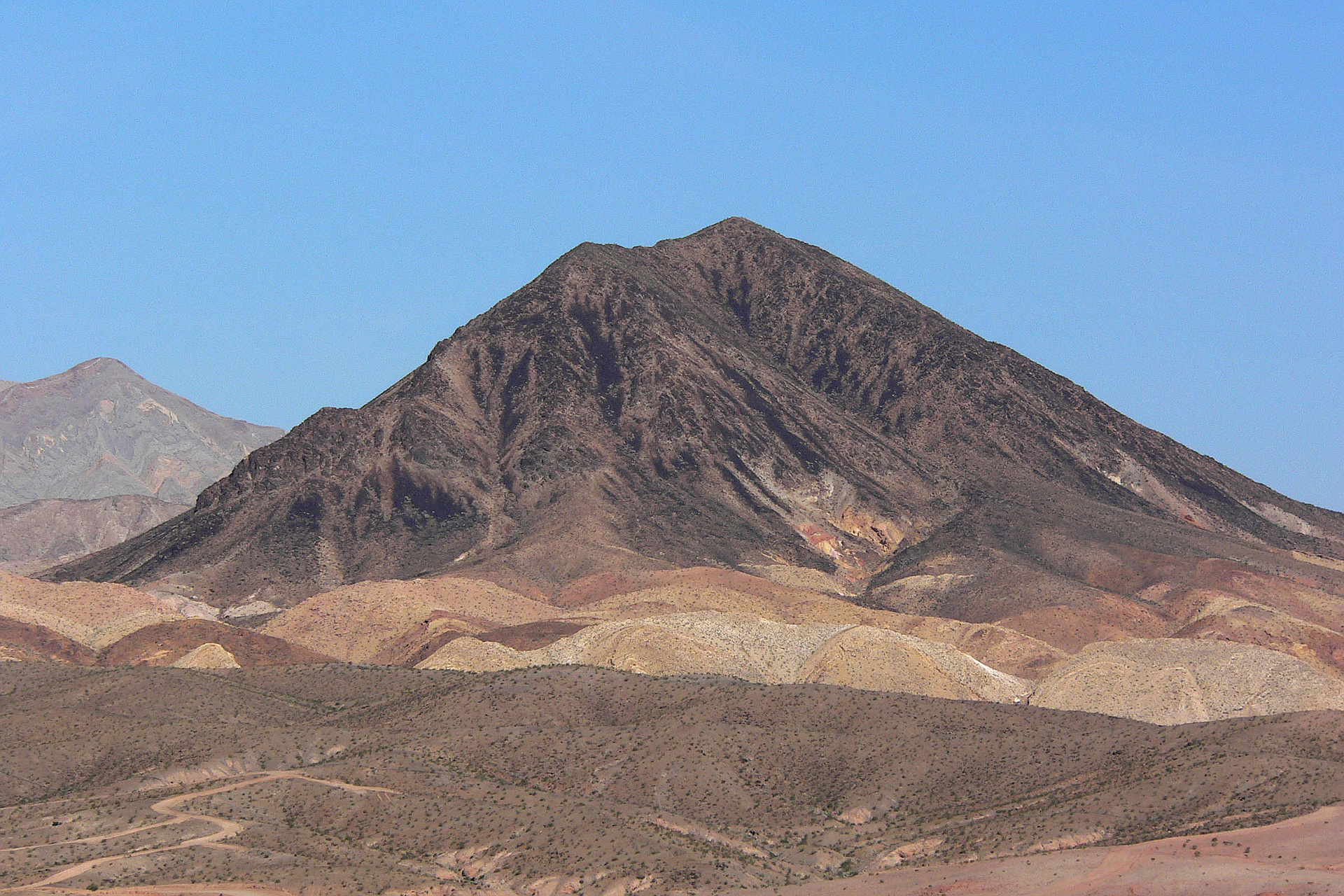
"First of all, you need to have access to a 4-wheel or all-wheel drive vehicle with at least some clearance. The climb is very tough as there is not true trail and you're hiking up and down loose rock and large boulders the whole way. We hiked across the face, in the first picture, just to the left of the black numb on the right. Then up the ridge from there. A hiking stick is recommended, for stability, especially coming down. " — GMan • Jan 11, 2020

"Gosh it's steep! Took the winding power line road/Lava Butte Road off of Lake Mead Boulevard (technically outside the fee area). There were several wash-outs on the road we chose, so we had to wander back to the larger powerline road to get to the starting point of the hike. Two other people started the hike a few minutes before we did, so we shared the summit the whole time. Very steep - about 1100 feet of gain in 0.8 miles. But what a view...! A nice day. Didn't feel so bad. I guess the running is helping? " — psychikingjes • Dec 21, 2019

"I Went on a NYD peak tour. I was nearly finished the 5 peak cluster near Dutchmans Pass after yesterday 3 peak hike. 4th out of 5 was the Jack. I took the Durango for a closer approach. I Went up a creepy shotgun shell and trash littered canyon, scrambled up a rough talus slope using some sheep trails and then up the loose serrated shale covered summit. It was a tough route for the 1.75 miles/500' gain round trip. The hillbilly's shooting guns and the sound of bullets wizzing through the canyons made it even more unnerving. I left there and picked up my sister for a late day (1st time for both of us) peak of Lava Butte. Wow! The views on that one were the best that I've seen of that area ever!!!! It far exceeded my expectations! We finished right at dark! Great NYD!" — paula.raimondi • Jan 1, 2017

"Amber, RD & I hiked up here because neither of them had been here before. The flagpole on top had snapped & was lying on the ground. RD & I were able to stand it back up and pile some rocks to hold it upright through the strong winds. We took the faint path up the NE ridge from the power line road." — Kevin • May 7, 2016

"Short scramble with my wife and a buddy. Wouldn't attempt without 4WD. From the powerlines we gained the saddle and then followed a faint path on the northeast ridge. Very steep and loose. Took longer going down than it did going up. The climb up was a pretty fun scramble and a great workout. Going down was not particularly fun with the very loose rock. Lots of solitude on this one, we were alone and the summit register seems to get about one group every week or so. Terrific views from the top. Elevation gain is about 1,200 feet. There are better hikes and peaks in the area, and probably won't be doing this one again any time soon, but glad to bag this nice little mountain. " — cardsfanlv • Dec 8, 2012
Photos
Awards
Challenges
About peakery awards
Log successful summits on peakery to earn awards:
Peak Badges: Earn a special badge for each unique peak you summit. See all of your badges on your Badges page.

First Ascent Award: Only 1 available per peak. Goes to the first peakery member to log a successful summit of a peak. Snag this award and the peak will forever bear your name.

King of the Mountain Award: Only 1 available per peak. Summit a peak more times than any other member. Beware: this award can be lost!

Summit Steward: Summit a peak at least 5 times to become one of its Summit Stewards. As Steward of a peak, you’re encouraged to keep that peak’s info up-to-date on peakery and spread goodwill on your future climbs up the peak.