

Region
Highlights
Routes
2 climbs • 8.1 mi • 2,995 ft gain • 7 hr 32 min
2 climbs • 4.4 mi • 2,105 ft gain • 3 hr 28 min
2 climbs • 7.2 mi • 4,181 ft gain • 7 hr 24 min
2 climbs • 4.6 mi • 2,670 ft gain • 5 hr 26 min
1 climb • 4.5 mi • 2,153 ft gain • 5 hr 29 min
Latest climbs
"Started on Stanley B. Springs trail - wanted to see if it was snowy, muddy, wet, etc. Was mostly dry, just a patch of snow below the mine, and a few patches afterward, especially between the saddle and the peaks. But overall, unexpectedly easy going (I had heard complaints it was difficult, with hard scrambling), with a trail all the way to Cockscomb, a nice surprise. Some steepness and loose ground/rocks on the way up from the saddle, but nothing worse than any other peaks and easier than some! Pleasant side trip to Fletcher Jr. on the return, again fairly easy going. Found 2 summit cairns and peak registers there, one named Fletcher Jr. and the other Diamond Peak, after a beloved pet cat. I guess it was named Fletcher Jr. several years earlier. Descent from Fletcher Jr. was the roughest part of the trip, just bushwhacking downhill. " — tracyt • Mar 12, 2026
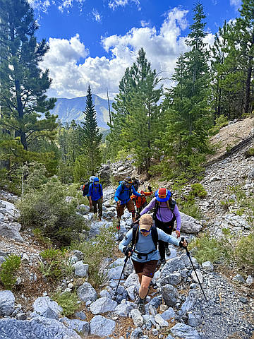
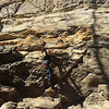
"On this 8 mile loop you will hike through a beautiful limestone slot canyon, a heavily treed forest with a seasonal stream, do some rock climbing and enjoy 360 degree views that are unique to the route. The track that is attached has a very challenging exit. Please, be aware that there are sections of loose, steep rock walls that you will have to descend. The initial descent from Fletcher Jr was a little too far south. I have climbed up a less rocky area that is about 1/3 of a mile from the peak, following this track. I highly recommend using that for the initial exit and joining up with the route on the attached track farther down. There is Class 3+ on the exits on this side of the mountain. A more friendly exit is to go down the gully that runs NW off of the peak. It will be steep, but easier. It will go down to the top of a wall, where Fletcher Canyon is below you. When you see that is going to drop off, go left into the trees a few hundred feet and you'll come to a steep chute that will take you into the bottom of the canyon, where you hike out on the Fletcher Canyon Trail. Most of the routes that I post are advanced routes that could involve rock climbing or navigating steep, ..." — Heartattackbruce • Aug 16, 2025

"Always looking for ways to make the most out of one hike. These three peaks are an easy link-up. The exit route we took back down to the Stanley B Springs trail from Fletcher Jr was a little steep with talus and scree and brushy in places, but overall a decent route. We didn't follow the "standard" Stanley B route up. At the Spring we went left and when that canyon ended we tried to stay on as much rock as possible, avoiding a lot of the vertical scree. All in all, a route that I would do again. " — Heartattackbruce • Sep 24, 2024
"6.11.24~Cockscomb peak & Cockscomb South Ridge via Stanley B Springs. 4.5 miles, 2,500’ gain. Harlan showed me this route years ago and it’s really neat. I’ve done slightly different variations over the years and this outing was a little diff too. We took the left fork all the way to the head of that canyon and the place we/I chose to exit was a little terrifying. We went up different parts as to not drop rocks on each other and we each went thru it…we reunited on top near the normal ridge herd path route. I don’t recommend staying in that canyon that far & leaving the canyon where we did. It was loose, unstable next to drop offs and my section required a short class 3+ escape on crud rock. His was terrible too. We were both worn out from that part and from the heat but neither of us said anything. We had a snack, shook it off and that kept the vibe good and we continue on. Laszlo hadn’t done the South Ridge (or this route to cockscomb) so we made it a combo. He took a scary way up towards South Cockscomb. I considered it, then looked at the standard way up to make sure I could come down that way, then followed his way up that short section with the terrible, creepy exposure to my ..." — paula.raimondi • Jun 11, 2024

"I rarely contribute here, but I am trying to be helpful! I went the reverse of normal; the normal route is clockwise, and the route-finding looks very different. I went up the south ridge, down the SE side. I've likely been up cockscomb at least 15x since 2003." — hwstock • Aug 26, 2022
Photos
Awards
About peakery awards
Log climbs on peakery to earn awards:
Peak Badges: Earn a special badge for each unique peak you summit. See all of your badges on your Badges page.

First Ascent Award: Only 1 available per peak. Goes to the first peakery member to log a successful summit of a peak. Snag this award and the peak will forever bear your name.

King of the Mountain Award: Only 1 available per peak. Summit a peak more times than any other member. Beware: this award can be lost!

Summit Steward: Summit a peak at least 5 times to become one of its Summit Stewards. As Steward of a peak, you’re encouraged to keep that peak’s info up-to-date on peakery and spread goodwill on your future climbs up the peak.