
Region
Most climbed route
Highlights
Routes
1 climb • 11.9 km • 4,314 m gain • 9 hr 54 min
1 climb • 11.9 km • 4,371 m gain • 9 hr 50 min
1 climb • 17.8 km • 5,482 m gain • 16 hr 9 min
1 climb • 19.0 km • 5,469 m gain • 8 hr 48 min
Latest climbs

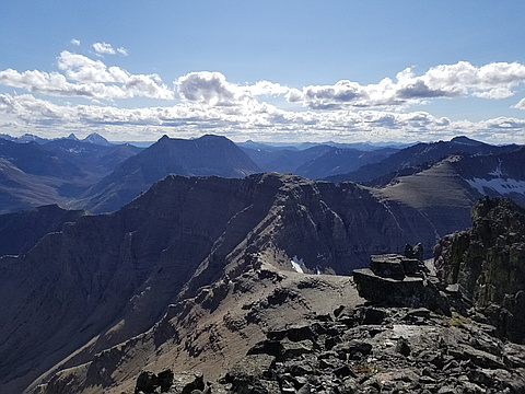
"Alda, Sim and I went up Dundy Peak, and traveresed to Cloudy Ridge. Fair amount of route finding is required. There is also a short climbing section. We took off our backpacks, Sim went up, and pulled each backpack up. This made it easier to climb. Traverese to Cloudy ridge made us avoid harder parts on the lefthand side. " — martawojnarowska • Sep 1, 2020

"Intent was to finish the day with Cloudy but time wasn't on our side. Moderate to difficult scrambling based on route-finding. Some class 5 moves on the ascent to Dundy. Dungvaran was a beauty - followed Nugara's Alternative Ascent route as it seemed a safer option that the Gulley Ascent." — carreradawn • Jul 11, 2020

"Had a late start and chose the wrong gully at first to ascend dundy peak. Had to make the decision to cut out cloudy ridge. A couple class 5 bands to break through in the ascent gully to dundy otherwise lots of scrambling to be had on this trip! The gully to Dungarvon summit has a couple route options however the easiest seems to have a chockstone jammed in it now, the other is highly exposed and difficult. We used the alternate route nugara describes and is leads to an awesome ridge scramble to the summit." — ken_hercules • Jul 11, 2020
"The plan was to do a Castle Wildlands PP Front Range Traverse starting in the south that included a bit of Waterton National Park. If we went from Lakeview Mountain all the way to Victoria Peak as one long ridge walk it would be 48km. The crux was likely the section up the southeast of Mt Dungarvan thru Cloud Ridge and Mt Glendowan and I couldn't find any reference on the web to anyone that had traversed the full distance between those peaks nor who had ascended Dungarvan SE.
After dropping bikes at the exit ridge of Victoria Peak and one further south near Loaf Mountain ridge, we drove the van up an unmaintained range road north of Lakeview Mountain and headed out on the prairie at a healthy 11am towards the start. We ascended the east valley towards The Horn deciding not to ascend Mt Dungarvan east face (good choice) which looked like continuous loose, steep terrain and looked back at the Horseshoe Basin trail switchbacks which became very evident from above with all the burnt out forest and emerging green grasses and flowers. On the summit by 2:30pm, we then looked at our first difficult objective.
Descending 200m to the col, we crossed snow and headed up the SE ridge and ..." — alexjoseph • Jun 29, 2019
Photos
Awards
About peakery awards
Log climbs on peakery to earn awards:
Peak Badges: Earn a special badge for each unique peak you summit. See all of your badges on your Badges page.

First Ascent Award: Only 1 available per peak. Goes to the first peakery member to log a successful summit of a peak. Snag this award and the peak will forever bear your name.

King of the Mountain Award: Only 1 available per peak. Summit a peak more times than any other member. Beware: this award can be lost!

Summit Steward: Summit a peak at least 5 times to become one of its Summit Stewards. As Steward of a peak, you’re encouraged to keep that peak’s info up-to-date on peakery and spread goodwill on your future climbs up the peak.