Highlights
- Mount Mitchell is the highest peak of the Appalachian Mountains and the highest peak in the eastern United States.
- Was the highest point in any state of the United States until Texas joined the union in 1845.
- The nearest higher point east of the Rocky Mountains is Harney Peak in the Black Hills of South Dakota.
- Protected by Mount Mitchell State Park and surrounded by the Pisgah National Forest.
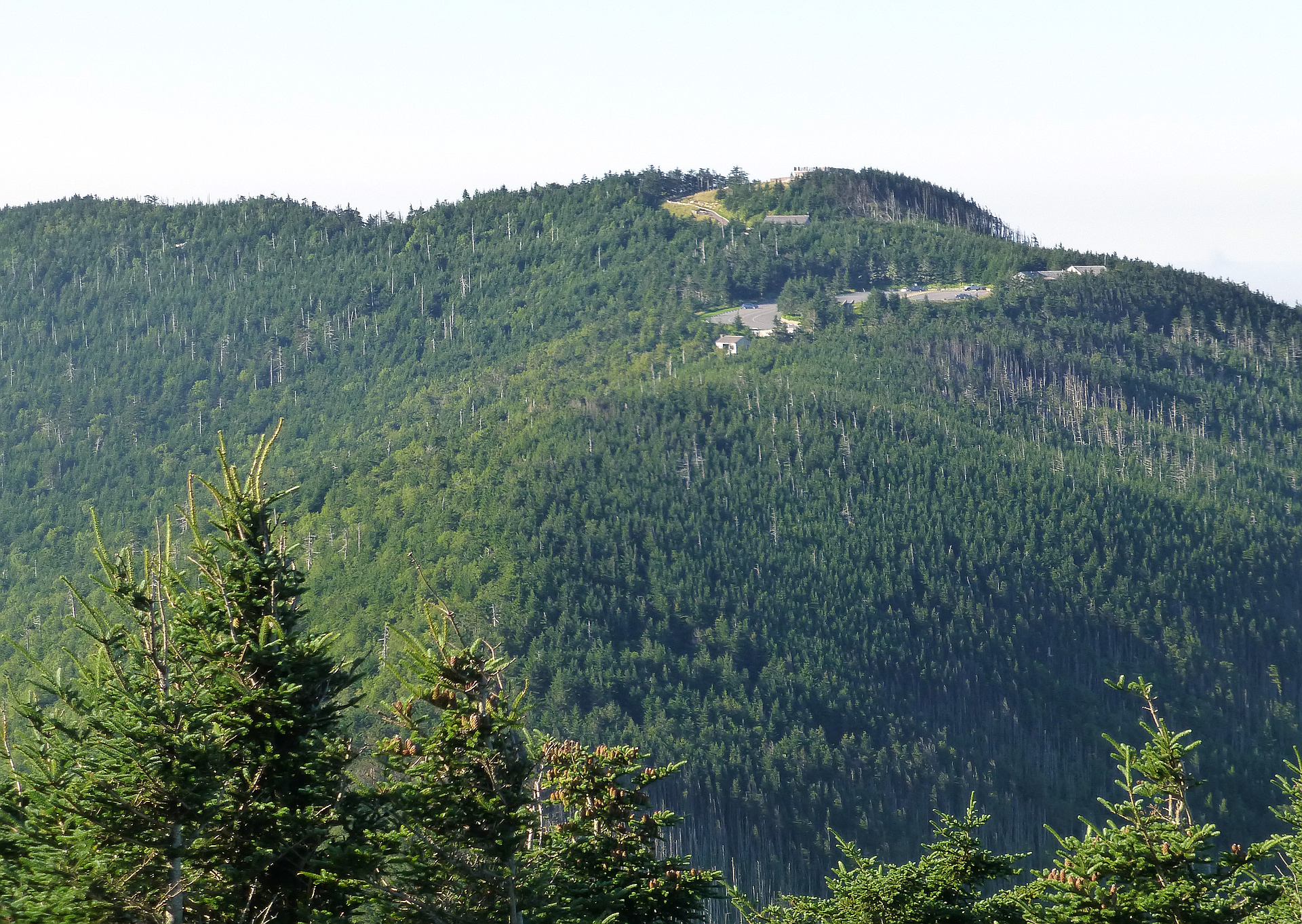
- A road leads to within 980 ft of the summit (lame) but at least everyone has to hike the last 980 ft.
Routes
/-82.2651601022866,35.7649126563535,11,0.00,0.00/320x240@2x?access_token=pk.eyJ1IjoicGVha2VyeSIsImEiOiJjampra3Z0bnAxeTVnM3FteHlybHY3b2p1In0.7a5dEa5-995VUv8ceHHNmw)
22 summits • 0.7 mi • 93 ft gain • 27 min
20 summits • 13.1 mi • 4,119 ft gain • 5 hr 57 min
8 summits • 9.8 mi • 2,521 ft gain • 5 hr 58 min
3 summits • 12.3 mi • 3,557 ft gain • 6 hr 44 min
2 summits • 1.6 mi • 114 ft gain • 45 min
1 summit • 12.1 mi • 5,085 ft gain • 17 hr 38 min
1 summit • 13.7 mi • 3,393 ft gain • 6 hr 54 min
1 summit • 19.4 mi • 4,419 ft gain • 14 hr 50 min
1 summit • 8.4 mi • 1,567 ft gain • 3 hr 17 min
Latest summits

"Spent most of the morning trying to find a pancake place in Pigeon Forge that didn’t have a half hour wait (daddy promises were made and I had to pay up). Then took the Blue Ridge Parkway out for a long haul to the highest mountain east of the Mississippi.
Mount Mitchell was the highest mountain of the United States until 1845 when Texas joined the Union and Guadalupe Peak became the highest mountain of the USA.
We cheated and drove to the top, then walked the 300 yards to the observation tower." — wiweasel • Nov 25, 2023

"I was the only one at the peak that morning. Watched the sunrise from the top. Was really spiritual and uplifting. After chilling at the top for awhile I decided to climb mount Craig as well. The hike wasent too bad but a spicy slim Jim I had that morning made my stomach a wreak. That brings me to my next point. No bathrooms at the top so make sure you go at the small ranger station at the bottom of the hill. " — MonMonKack • Mar 1, 2023

"Drove the Blue Ridge Parkway on a picture perfect fall day. Sunny clear blue sky and tree covered mountains showing off some fall colors. Parked in the lot and walked up the summit trail. Great views from the observation deck. We will definitely be back to do a nice long hike up there next time." — jodola • Oct 6, 2022

"Did the short walk up the 320 foot paved path to the summit lookout from the top of the summit road. Glad that the road was open in March while we were in the area. BRP was closed in one direction so had to take a long way around but totally worth it. Another high point now visited!" — SteveG • Mar 20, 2022

"Bagged Mitchell and Craig via Mount Mitchell Trail.
The trail isn’t technically difficult, but it’s surprisingly steep, and the profusion of roots and rocks prompted me to buy trekking poles for future hikes.
Summiting Mitchell is odd. After nearly 6 miles of hiking in serene wilderness, you arrive at the busy path that connects to the parking lot most people drive to.
After taking in that crowded summit I made my way across the ridge to the vacant top of Mount Craig." — tylerdelia • Oct 21, 2021

"2nd HP for the day, cam from Mt Rogers. Nice drive to the top, couldn't see anything though, weather had come in and completely covered the mountain, could nearly see 30 feet. " — CravinoCrew • Apr 8, 2021

"Hiked Old Mitchell Trail from park restaurant to paved trail from museum to peak. Trail starts up over a hill then down along steep side of the mountain below the park campground before rising to meet the campground trail. The section of the trail below the campground is like an obstacle course with steep steps and a knotted rope for a fun workout. On the way back down we skipped a second round through the obstacle course by taking the much easier campground trail to the road, getting back on Old Mitchell Trail where it comes near the road. Trails are soft dirt with some gravel, roots, and lots of rocks and boulders. " — davidensley • Nov 22, 2020

"After my rest and snack stop at Big Tom I hiked back up over Mt. Craig to the Mt. Mitchell pkg. lot. I wanted to get a proper summit picture so I walked up the summit of Mt. Mitchell a second time! My 6th state HP this trip." — SteveM_StickMan • Jun 26, 2020

"After my 3 peaks in Great Smoky Mt. N.P. in the morning, I drove the 5 1/2 hours to Mt. Mitchell State Park to see what I could do this afternoon. I wanted to summit Mt. Mitchell first, then hopefully add Mts. Craig and Big Tom to the list. Since it was only about 1/4 mi. from my pkg. spot to the summit, I was excited to get some good views that I hadn't at Clingmans, since the sun was out with some clouds. The modest observation deck isn't quite as imposing as Clingmans, even though Mt. Mitchell is the highest peak in the eastern half of the U.S. Nevertheless there are still a lot of tall trees on top of this mountain so the deck helps you see the surrounding area better. After taking videos of the great views, I returned to the pkg. lot and found the Deep Gap Trail leading north toward Mts. Craig and Big Tom." — SteveM_StickMan • Jun 26, 2020

"Visibility was terrible. The whole mountain was wrapped in a cloud. Cold (36 degrees fahrenheit!) and windy. Couldn't find the benchmark - where did it go? I bet this place would be very pretty on a clear day! State highpoint #8 for me, #2 for my mother!" — psychikingjes • Mar 30, 2018
Photos
Awards
Challenges
About peakery awards
Log successful summits on peakery to earn awards:
Peak Badges: Earn a special badge for each unique peak you summit. See all of your badges on your Badges page.

First Ascent Award: Only 1 available per peak. Goes to the first peakery member to log a successful summit of a peak. Snag this award and the peak will forever bear your name.

King of the Mountain Award: Only 1 available per peak. Summit a peak more times than any other member. Beware: this award can be lost!

Summit Steward: Summit a peak at least 5 times to become one of its Summit Stewards. As Steward of a peak, you’re encouraged to keep that peak’s info up-to-date on peakery and spread goodwill on your future climbs up the peak.