
Region
Highlights
Routes
33 climbs • 9.6 mi • 3,618 ft gain • 4 hr 1 min
Latest climbs
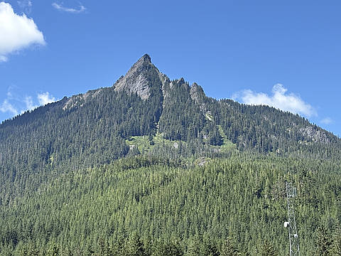
"Complete cloud cover at the top, but had I waited 30 minutes I'd likely would have had some beautiful views. The scramble was fun. Nice and efficient uphill on this one, would put it in the same I-90 shuffle category as PPP. Will check it out again." — zachmitch • Jul 12, 2025

"4 hours up, 30 minute summit snack, 3 hours down.
First snow at around 3400 feet, lots of snow on the avy chutes. After the last avy chute, almost entirely on snow. Route finding on the backside traverse not trivial. Snow slope up to the summit ride near 45 degrees. But rock on summit block solid and dry." — mathiasricken • Jun 4, 2023

"2nd trip this year - finally without snow. Made the summit block. The trailhead had one car at 10:30 AM. The trail is in great shape, with the exception of 4 blowdowns - three are at the trail junction where it turns back North to the summit on the Southern side facing the Cedar River watershed - no issues traversing the downed trees. Once you cross FS Road 9020, the steepness begins - long switchbacks and longer sustained stretches will provide for a good workout, as between 2-4 miles is where you will gain the most elevation. The West part of the trail headed North to the summit is perhaps the most enjoyable - mostly level with great views of mountain meadows and ponds.
My pictures in the report are intended for those who have not climbed the summit and are interested in the summit block challenge. When dry it's a reasonably easy scramble. See pics of the ascent, the initial part of the block and summit itself. The initial part of the block is the most difficult and intimidating. Just follow the line up keeping mostly to the left. You will see remnants of former iron poles in the rock - maybe these were used to tie in or had chains - this is the best way up - so tr..." — markhadland • Aug 31, 2018

"The third avy chute was mostly melted out, but it was still easy to cross, just a bit higher in the chute. No ice axes. Two of us had mountaineering boots, one sneakers and microspikes." — mathiasricken • Jun 16, 2018

"Rainy day hike with my friend Jessie to McClellan Butte, McClellan Butte South Peak, Point 4787', Chester Peak and the bump between Chester Peak and Point 4787'. The wind was really whipping at the summit of McClellan and then snow started coming down practically sideways for my scramble back down to the trail just to keep it interesting. We had hoped to drop down the ridge from the unnamed bump to Truck Summit and then make our way down to the Hall Creek Trail for a Point A to Point B hike, but the ridge was extremely choked with immature trees that would have made for some really slow going, so we opted to just retrace our route back down the McClellan Butte Trail." — Al-Rashid • Oct 29, 2016

"Gorgeous last day of spring. My buddy Paul and I arrived at the trailhead happy to see that although the trail was closed tomorrow to clear some blowdown, it was open today and that's all that mattered to us! One large tree in particular fell directly along the trail for a stretch of 30 feet or so, but that should be gone by the time anyone is reading this.
Most of the trail is snow free. There was some patchy snow near the top with good steps kicked in. Trekking poles were helpful, but no traction devices or axe necessary. The snow bridge in the first gully has collapsed but you can easily make your way around it. The snow bridge in the second gully is near collapse and definitely wouldn't hold a person's weight. It's easy to make your way down into the gully and there's a fixed rope for assistance up the steeper, opposite side, though we were easily able to follow steps someone had kicked into the snow up the slope without a need for the rope.
We relaxed on the summit for a while and took in the unobstructed 360 degree view of the area. We especially enjoyed the view of the whole length of West Defiance Ridge, which we traversed together last summer. After gett..." — Al-Rashid • Jun 19, 2016

"Cool climb of McClellan with the boys and Nick and Mike. Scrambled to the top, and spent an hour teaching the boys ice axe self arrest. Snow gulleys with lots of water running underneath still..." — BryHong8 • May 30, 2016

"Drove our car up the FSR to cut the hike short to 8.5 miles. Ran into snow pretty quickly, but it wasn't too bad for most of the trail - didn't really need gaiters. Didn't do the last scramble to the top as it was too sketchy in the snow - a fall in any direction would have meant certain death! " — North-Bend-Erica • Apr 12, 2015

"
The first half of the trail up is in good shape and is easy to follow.
The avalanche chutes still have some snow in them but are easy to pass thru.
I made it to the ridge, where the trail takes a hard right turn back towards the top, without much difficulty.
Once you reach the ridge... I went straight up the ridge for a 75 yards or so and then dropped down 100 to 200 feet (varied at times) onto the west slope and into the snow. From here to the top I never really found the trail again. There is alot of firm snow. Needless to say ... route finding becomes difficult.
" — JakeRC • Jun 16, 2013

"Spent most of the hike in clouds and fog until the last 500 ft...where I got above the cloud line and then had the pleasure of eating lunch on the peak above the clouds. Awesome moment. " — Snowcarcass • Oct 11, 2011
Photos
Awards
Challenges
About peakery awards
Log climbs on peakery to earn awards:
Peak Badges: Earn a special badge for each unique peak you summit. See all of your badges on your Badges page.

First Ascent Award: Only 1 available per peak. Goes to the first peakery member to log a successful summit of a peak. Snag this award and the peak will forever bear your name.

King of the Mountain Award: Only 1 available per peak. Summit a peak more times than any other member. Beware: this award can be lost!

Summit Steward: Summit a peak at least 5 times to become one of its Summit Stewards. As Steward of a peak, you’re encouraged to keep that peak’s info up-to-date on peakery and spread goodwill on your future climbs up the peak.