
Region
Highlights
Routes
5 climbs • 11.8 mi • 6,614 ft gain • 7 hr 26 min
1 climb • 7.7 mi • 4,152 ft gain • 5 hr 28 min
Latest climbs
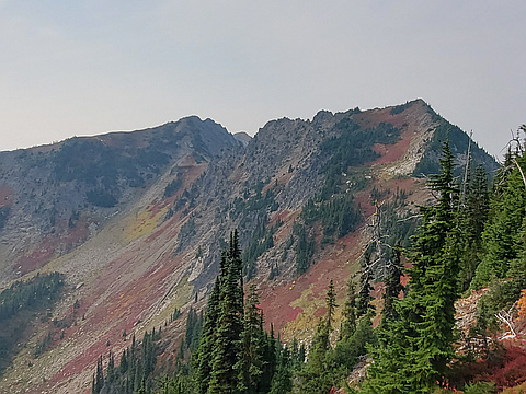
"Hot, smoky day climbing these peaks. Routes are straightforward though Howard was a bit tedious for the final few hundred feet as I took the wrong route and had to boulder hop instead of finding the climbers path, which you can see on my descent track." — stukesowle • Oct 1, 2020

"A warm-up day that got a bit out of control with over 7,000 vert.
En route to Mt Howard, Josh and I flew up the never-ending switchbacks to Rock Lake and decided to add on the short-ish climb to Rock Mountain. Great summit views north toward Glacier Peak, only issue was swarms of flying ants ONLY on the summit.
We then took the Nason Ridge Trail over and down to Crescent Lake at the base of Mt Howard. From here it was off-trail bushwack-y routefinding through some cliff bands to broad alpine meadows to talus fields to the summit. Great, very similar views again, and again swarms of flying ants, this time ONLY on the very highest summit rock. Flying ants must love summits, perhaps they’d like peakery?
Time started to slow on the long trek back down… then up… then across… then down forevvvvvver in a bonking dizziness. The bluebird day turned dark and rain started — but only in the last few minutes of the descent. We played the weather perfectly (or did it play us?).
To cap a great day, we hobbled out of the car to grab humungous milkshakes at a stand off route 2 towards Leavenworth (highly recommended — you can’t miss the gigantic MILKSHAKES sign). When the absurd sugar r..." — scott • Sep 7, 2018

"We left Renton at 4:30 a.m. and left the truck under the power lines East of the Rock Mountain Trailhead at 7. We scrambled quickly up to the trail and started up the endless switchbacks. As we climbed, a red glow moved into the foggy valley to the East and Icicle Ridge slowly rose from behind the Chiwaukum Mountains. Snow began to appear on the trail by 3500 feet. We carefully worked through few short sections of exposed switchbacks that were covered in thick ice before.
Where snow covered the trail it was fairly well packed, but as we gained elevation and the untouched areas remained soft powder it became increasingly clear that we should have brought snowshoes. We followed the sole pair of boot tracks on the mostly packed trail until they turned around, and continued on the trail for a few hundred feet more until reaching an exposed rocky peak. We crossed below the cliffs and then climbed to the top of the ridge where the false summit of Rock Mountain first came into view.
The surrounding trees thinned as we approached the ridge South of Rock Lake, and our steps grew deeper in the sun-baked snow. We took a break on the ridge above the lakes outlet and discussed the route ..." — Jeb • Nov 23, 2013
Photos
Awards
About peakery awards
Log climbs on peakery to earn awards:
Peak Badges: Earn a special badge for each unique peak you summit. See all of your badges on your Badges page.

First Ascent Award: Only 1 available per peak. Goes to the first peakery member to log a successful summit of a peak. Snag this award and the peak will forever bear your name.

King of the Mountain Award: Only 1 available per peak. Summit a peak more times than any other member. Beware: this award can be lost!

Summit Steward: Summit a peak at least 5 times to become one of its Summit Stewards. As Steward of a peak, you’re encouraged to keep that peak’s info up-to-date on peakery and spread goodwill on your future climbs up the peak.