Region
Highlights
Routes
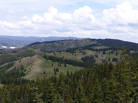
/-106.456789970398,36.977632433334,11,0.00,0.00/320x240@2x?access_token=pk.eyJ1IjoicGVha2VyeSIsImEiOiJjampra3Z0bnAxeTVnM3FteHlybHY3b2p1In0.7a5dEa5-995VUv8ceHHNmw)
1 summit • 5.2 mi • 1,247 ft gain • 4 hr 26 min
1 summit • 4.9 mi • 1,073 ft gain • 3 hr 43 min
Latest summits

"I thought I had all 75 of the 11K peaks in New Mexico. (A very inclusive list) A new type of very accurate contour elevation analysis has recently come on the scene, recalculating many new high points throughout the country. This has messed up many peoples’ peakbagging lists. This new peak height analysis is called LIDAR, which stands for Light Detection and Ranging. This is remote sensing technology that uses a laser beam to very accurately measure high points in an area. So far, it has only messed with one of my mountain peaks, Peak 11,077/70/60. The new area high point is Peak 11,078 and it is 1.5 miles away from the other, as the crow flies. So……….
I left from the house of the peakbagger with the designated screen name Swithich, Labor Day 5:45 AM, September 4, 2023. We had to drive all the way to the Colorado border, then come back into northern New Mexico through some backwoods’ roads. To get there, just before Antonito, Colorado turn west on Highway 17 and go 34 miles, then turn south on to Highway 117, to Forest Road 686 to coordinates 36.9776 -106.4475 . There are about 6.5 miles of dirt road after turning off of Highway 17. The first half works for a passenger car, but..." — Phil-Robinson • Sep 4, 2023
"I left the house at 5:00 AM, July 11, 2013, and headed to Santa Fe then Espanola then north on highway 285 to the town of Tres Piedras. It took about 2 and ½ hours. I met fellow peakbagger Richard O. and we took his Jeep and headed to the Colorado Border. We went to the town of Antonito then headed west following near the route of the Cumbres and Toltec narrow-gauge railroad. Not long before highway 17 returns to New Mexico we turned left on a dirt road that appears to be where Forest Road 87 exits New Mexico. After testing a few roads, and crossing back into New Mexico, we found Forest Road 686 that led us to within a half mile of Peak 11070. This is about 6 or7 miles from the paved road. Some of the road is accessible by any vehicle but the last couple of miles is a tough 4 wheel drive road. It took us about 2 and ½ miles from Tres Piedras, but we spent 30 extra minutes hunting the correct road.
It was a beautiful morning! We started hiking at 10:30 AM. The starting elevation was 10716. We followed the road to the west for a short distance then were quickly bushwhacking. It only took eight tents of a mile to get to the peak. It took about 40 minutes. The peak was clear of..." — Phil-Robinson • Jul 11, 2013
Photos
Awards
About peakery awards
Log successful summits on peakery to earn awards:
Peak Badges: Earn a special badge for each unique peak you summit. See all of your badges on your Badges page.

First Ascent Award: Only 1 available per peak. Goes to the first peakery member to log a successful summit of a peak. Snag this award and the peak will forever bear your name.

King of the Mountain Award: Only 1 available per peak. Summit a peak more times than any other member. Beware: this award can be lost!

Summit Steward: Summit a peak at least 5 times to become one of its Summit Stewards. As Steward of a peak, you’re encouraged to keep that peak’s info up-to-date on peakery and spread goodwill on your future climbs up the peak.