
Region
Highlights
Routes
7 climbs • 11.0 mi • 2,912 ft gain • 4 hr 51 min
Latest climbs

"Parked where Palm Avenue ended and Forest Road 2N49 began. The forest road served as my wide trail all the way to the summit. The road splits at a saddle between Flat and Monument Peak. I took the road to the left there and hit the summit shortly thereafter. Was surprised to see a pickup truck sitting on top with some guy strung out in the back recovering from a long night of partying. I wanted to do other nearby summits, but as usual I had other places to go today." — MikeTeeples • Oct 6, 2019
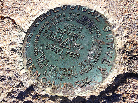
"Fourth and last attempt to find the Flat Benchmark, and as of now, I declare it "impossible to locate." According to the USGS map, it lay just beyond a thicket of brush and bush. There were several overgrown paths going through, but all were impassable. So, I brought some long-handled pruning shears, and opened one of them up a bit. As I peaked beyond the thicket, I saw before me a field of thick chaparral. Somewhere in there was the benchmark, but I realized that I would need more than pruning shears to find it. I'd need a bulldozer. Well, I guess you got to let em go from time to time.
EDIT: After a bit of research, I have discovered that the Benchmark on Monument Peak is an Azimuth Mark associated with the Triangulation Station Mark lost in the chaparral at Flat. The discovery of Flat BM on geocaching refers to this mark, not the actual station. So, I suppose it's not a total loss." — jimduvall • Apr 11, 2015
"Last time, it was torrential rain. This time, it was gale force winds. That would be two of the four primary elements. So, next time I can expect either a landslide for a forest fire, I assume? Hopefully, I'll find the benchmark then, too. Damn." — jimduvall • Jan 24, 2015
"Second trip up there. Still didn't find the benchmark. It rained on my head, however, and so I didn't try too hard. I still think it's there to be found, among the many weeds and bushes. " — jimduvall • Jan 11, 2015
Photos
Awards
About peakery awards
Log climbs on peakery to earn awards:
Peak Badges: Earn a special badge for each unique peak you summit. See all of your badges on your Badges page.

First Ascent Award: Only 1 available per peak. Goes to the first peakery member to log a successful summit of a peak. Snag this award and the peak will forever bear your name.

King of the Mountain Award: Only 1 available per peak. Summit a peak more times than any other member. Beware: this award can be lost!

Summit Steward: Summit a peak at least 5 times to become one of its Summit Stewards. As Steward of a peak, you’re encouraged to keep that peak’s info up-to-date on peakery and spread goodwill on your future climbs up the peak.