
Region
Most climbed route
Highlights
Routes
1 climb • 8.6 mi • 1,381 ft gain • 4 hr 4 min
Latest climbs

"What a hike to end off the year. A lucky 7, I should say. Started at Cottonwood Fire Station, and my first targets were Flat and Monument. Approaching Bailey Canyon Road, I hear the winds. When I got up there, the winds were relentless to me with frozen mud puddles. Running through the pine trees blown, headed for flat. And it sure was flat with even aggressive winds. Going back up to Monument, I knew it would be a fight with the wind nonstop. Coming back where I turned off onward to Cajon, but first Sugarpine. I saw little dusts of snow, even on the ascent to Sugarpine, even on the mountain itself. Making it to Cajon, it was a forested road, but that didn't block the winds. Had a stop at the lookout before heading to the true summit. Was up there for a while but had to go. Coming down almost from the use trail, I fell. Still struggling with the cold coming back from the Bailey summits, was not alone. 2 Vehicles passed me by. Made it to the benchmark and then the last push up to the true peak. More snow was up there. With that wrapped up, I wonder what the future peaks will challenge me next." — ChristianFlowerstheczywildhikr • Dec 28, 2025
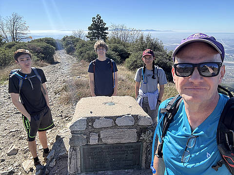
"Needed to work off the thanksgiving feast calories, so took the kids on this hike to knock out some more HPS peaks for myself. Getting to the trailhead was interesting: one way in is marked as a "private drive", so we went around to the northern entrance that had no such signage but rough dirt roads made me appreciate having a truck. The forest service road makes this overall hike fairly easy with Monument being the first peak, then Bailey Benchmark, then over to the actual Bailey, and ending at Sugarpine. Then take the road back to the trailhead." — marc • Nov 28, 2025
"Hiked up to the top of Bailey peak on the truck trail to the very top was very long and was just straight endurance but the views were absolutely amazing
Length 16.1 miles
Elevation gain 3,776 feet " — Socalhiker12 • Dec 7, 2024
"Been planning this one for a while. Finally, the right day and conditions fell in place. It goes without saying that it is a long hike. 90% of the hiking is on Forest Road 2N49. If I had a 4WD vehicle, I could drive to the peaks, park, and walk the short summit trails. What is key in order to do it that way is the 4WD vehicle (which I don't possess). Fortunately, I had 2LD (leg drive) and an open day. I Managed to complete the day with no more than a 5 minute break. It took all day, but each listed peak got checked off." — MikeTeeples • May 30, 2022
Photos
Awards
About peakery awards
Log climbs on peakery to earn awards:
Peak Badges: Earn a special badge for each unique peak you summit. See all of your badges on your Badges page.

First Ascent Award: Only 1 available per peak. Goes to the first peakery member to log a successful summit of a peak. Snag this award and the peak will forever bear your name.

King of the Mountain Award: Only 1 available per peak. Summit a peak more times than any other member. Beware: this award can be lost!

Summit Steward: Summit a peak at least 5 times to become one of its Summit Stewards. As Steward of a peak, you’re encouraged to keep that peak’s info up-to-date on peakery and spread goodwill on your future climbs up the peak.