
Region
Highlights
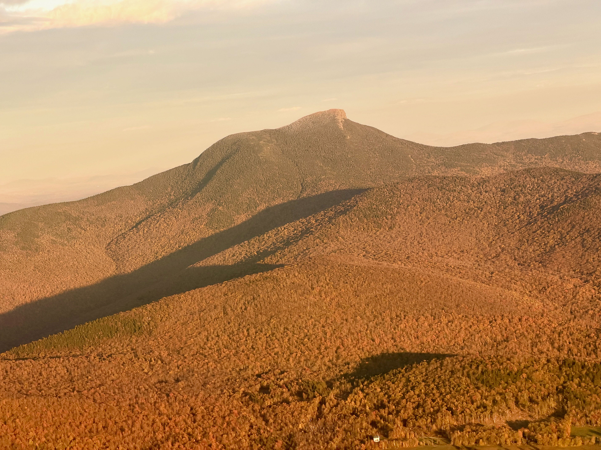
- Camels Hump is located in the Green Mountain Range and is Vermont's third-highest mountain and highest undeveloped peak.
- Camels Hump is more notable for its shape than its height; the mountain's conical silhouette is distinctive.
- Because of its distinctive profile it is perhaps the state's most recognized mountain.
- The hiking trails on Camels Hump were among the first cut in the Long Trail system and Camels Hump remains a popular summit for through- and day-hiking.
- The summit of Camels Hump is home to 10 acres of alpine tundra vegetation.
- The views from the summit are panoramic, and on a clear day one can see Mount Marcy in New York, Mount Washington in New Hampshire, and Vermont's Mount Mansfield, the highest peaks of these three states.
- The Long Trail traverses its summit.
- The mountain is part of Camel's Hump State Park.
Routes
37 climbs • 4.7 mi • 2,159 ft gain • 4 hr 23 min • Class 1
20 climbs • 6.6 mi • 2,530 ft gain • 5 hr 4 min
12 climbs • 6.2 mi • 2,553 ft gain
10 climbs • 8.8 mi • 2,636 ft gain • 2 hr 50 min
3 climbs • 4.7 mi • 2,283 ft gain • 3 hr 15 min
2 climbs • 5.6 mi • 2,334 ft gain • 3 hr 45 min
Latest climbs
"Today's adventures took Lisa Crandall and I to the 3rd highest mountain in Vermont, Camels Hump on hump day @ 4080ft. Another warm one but got the mountain views this time, almost clear skies. Lisa and myself enjoyed this one and made it a loop going up the Forest city trail and down the Burrows trail making it a loop back to the parking lot, 2 down and possibly 3 more to go, fingers crossed we have the gas to get it done, doing what we love" — ramjet1963 • Jul 2, 2025

"I needed a 4000 footer for a Calendar Day. I headed up the Forest City Tr, then up Burrows Tr. I bushwacked over to Bald Hill (turns out it is not bald) and had a unique view of Camel's Hump. I then bushwacked back down to the Burrows Tr, then up to Camel's Hump. Cold windy day today. I followed the LT north and descended down to the Alpine Tr. I then took that trail all the way, looping around Camel's Hump. I then took LT south and descended a lot down to the Forest City Tr. I then headed back to the car. I stopped at Stone Corral Brewing for a View and Brew. " — newenglandwarrior • Sep 9, 2024

"A great solo hike for my 4000 footer finish! Trail was in great shape. Took counter clockwise route up Forest City and steep Long Trail. Down the mild Burrows Trail. Nice views of the hump. Lots of people hiking today. Prized a bit of rain on the way down. " — lfrancois • Jul 29, 2024

"Good hike. Cloudy at the bottom but opened up by the time we summited. Had the summit to ourselves despite the crowd at the parking lot, starting late in the day has its perks.
" — bobbaker • Jun 4, 2023
"A Calendar Day hike for me. I went up the Monroe Tr to Alpine Tr South, then up the LT to the summit. I took the LT north and Monroe Tr back to the trailhead. It has been awhile since I was last here. Beautiful views and not much color anymore on the trees. I did see some frosty trees near the summit. " — newenglandwarrior • Oct 20, 2022
"Warm day in the 60's, light overcast. Started at Burrows Trailhead, took Burrows Trail up.
Muddy for first half up, turned to wet snow (needed spikes). At major junction, turned right onto Long Trail to a very windy summit, hazy in the distance so couldn't see Mt. Washington, but was able to see Mt. Mansfield, Whiteface, and others. Continued through summit on Long Trail to next junction. Turned left onto Alpine Trail for about 0.2 miles to the plane wreck. It was half-buried in snow but still very cool. Looped back to the junction and continue to descend via the Long Trail and eventually Forest City Trail back to the trailhead." — gregoryskiba • Apr 24, 2021

"Hiked the loop counter- clockwise, went out Forrest City to Long and back Burrows. This was definitely the best route for me climbing up the rocks and back down the easier Burrows trail. This was my favorite of the 5 over 4K. Beautiful views & fun climbs. I got the best weather too." — trussell • Sep 23, 2020

"Warm day but got an early enough start (started 8:15, arrived at summit just before 10, back to car by 11:05) that it wasn't bad. Ground was fairly dry so good traction and able to run much of it. Monroe Trail to Summit had a fair number of people per usual, but Dean Trail and Long Trail from Dean to Summit were empty. A passing shower came by just as we returned to trailhead. A very nice morning." — seansheehan • Jun 21, 2020

"An awesome day. Started mid-day/early afternoon on a 13-14 mile hike from River Rd south on Long Trail to Alpine Trail. All fresh snow on Alpine Trail from LT to Monroe with the exception of an animal (maybe a grouse?) that had followed the trail for several hundred yards, then past the plane wreckage to the LT and back north over the summit and back to River Rd., arriving just after nightfall... though a well-placed full moon spared the need for a headlamp. " — seansheehan • Apr 4, 2020

"Hot and humid is the theme of my Vermont adventure. Amazing views from the summit. I decided to call my 4k efforts finished for the trip as the heat and humidity finally got to me, leaving only Mansfield left to tackle in Vermont." — Right-On • Jul 5, 2019
Photos
Awards
Challenges
About peakery awards
Log climbs on peakery to earn awards:
Peak Badges: Earn a special badge for each unique peak you summit. See all of your badges on your Badges page.

First Ascent Award: Only 1 available per peak. Goes to the first peakery member to log a successful summit of a peak. Snag this award and the peak will forever bear your name.

King of the Mountain Award: Only 1 available per peak. Summit a peak more times than any other member. Beware: this award can be lost!

Summit Steward: Summit a peak at least 5 times to become one of its Summit Stewards. As Steward of a peak, you’re encouraged to keep that peak’s info up-to-date on peakery and spread goodwill on your future climbs up the peak.