Region
Most climbed route
Highlights
Routes
/-115.164256254269,51.0204242043713,11,0.00,0.00/320x240@2x?access_token=pk.eyJ1IjoicGVha2VyeSIsImEiOiJjampra3Z0bnAxeTVnM3FteHlybHY3b2p1In0.7a5dEa5-995VUv8ceHHNmw)
2 summits • 18.2 km • 1,738 m gain • 8 hr 29 min
1 summit • 13.6 km • 1,336 m gain • 5 hr 5 min
1 summit • 19.8 km • 1,212 m gain • 7 hr 44 min
1 summit • 26.6 km • 2,352 m gain • 10 hr 0 min
Latest summits

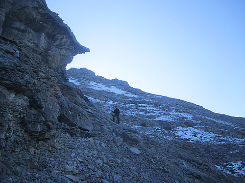
"After the easy hike plans fell through, I decided to get this one done. Loaded up the bike and went out. Biked a short bit but really didn't do much peddling as I pushed the bike most of the way. After the bike came the bushwhack. I was very glad I used a GPS. I ended up deviating from the initial plan which was actually of benefit. I went up one ridge, dropped over in to the next gully and worked it. I give the crux 4 out of 5 on the pucker factor. Downclimbing on small holds with loose debris while scootched down, with big exposure on the right, was tough. Had to focus. After that the descent was ok, tried to follow the water out and that worked for most part and then I had to go up, back into the woods as the water was going to cliff out. I ended back on the side where I came up and made it back to the bike. It was really nice to cruise downhill while being surrounded by wildflowers." — BertB • Jul 28, 2019
"After years of passing on this mountain but still having it on my to do list year after year I finally made it to the summit. GPS fail no battery power. With a sudden burst of energy after summiting and thinking I probably won't be up here again I decided to traverse to north buttress for the view before returning the same way. Possibly return someday but via Pigeon pass from the Skogan pass trail I think would be a nice route." — Randy • Jul 16, 2018
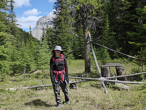
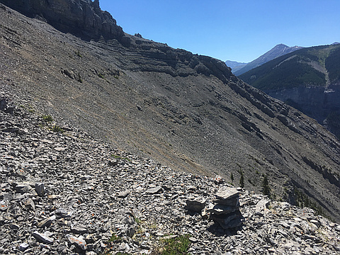
"Three in our group. Access via mountain bikes on the Skogan Pass northern side trail. Then hiked east through "Pigeon Pass" , going past a informal back-woods camp area, down through forest to McGillivray Creek, up a juniper and aspen clad hillside and up the southwest slabby flanks of Mt. McGillivray. Gradually turned clockwise / left / higher up and around to the north side of the summit pinnacles on blocky scree. Crested a loose, narrow and exposed ridge and arrived on the summit mid-afternoon. Enjoyed the views of Pigeon Mountain, Heart Mountain, the long barren white limestone ridge northwest of the summit and Skogan peak outliers south of us, then returned carefully down the same way we came up. Note the exposed loose narrow crux of this mountain - and the steepness of the Skogan Pass cycling trail." — geoffc • Jun 13, 2018
"Original objective was to traverse from McGillvary to Skogan to Lorette to Mary Barclay to Heart, to Twins. However, due to problems descending from Lorette to Mary Barclay we lost valuable time and had to descend into Heart Creek and then hike out in the dark. " — dkmountainman • Sep 3, 2011
Awards
Challenges
About peakery awards
Log successful summits on peakery to earn awards:
Peak Badges: Earn a special badge for each unique peak you summit. See all of your badges on your Badges page.

First Ascent Award: Only 1 available per peak. Goes to the first peakery member to log a successful summit of a peak. Snag this award and the peak will forever bear your name.

King of the Mountain Award: Only 1 available per peak. Summit a peak more times than any other member. Beware: this award can be lost!

Summit Steward: Summit a peak at least 5 times to become one of its Summit Stewards. As Steward of a peak, you’re encouraged to keep that peak’s info up-to-date on peakery and spread goodwill on your future climbs up the peak.