Region
Highlights
- On a recent survey in the park, I found an interesting plaque on the east side of the mountain about 5m below the summit on flat rock face. I’ve posted the picture K.Smith Dec.14, 2018
Routes
/-76.0374205931838,44.3718047190664,11,0.00,0.00/320x240@2x?access_token=pk.eyJ1IjoicGVha2VyeSIsImEiOiJjampra3Z0bnAxeTVnM3FteHlybHY3b2p1In0.7a5dEa5-995VUv8ceHHNmw)
4 summits • 8.0 km • 62 m gain • 4 hr 35 min
2 summits • 13.6 km • 113 m gain • 7 hr 6 min
1 summit • 4.4 km • 60 m gain • 3 hr 10 min
Latest summits

"Beautiful first day of spring hike. Wet conditions and windy. I bushwhacked from Ebenezer . I was able to strip down to a t-shirt , which was very refreshing. I remained on the summit for approx. 1/2 hour, built a inukshuk and wandered about ." — kencirtwill • Mar 20, 2020
"After last weekend's "recon mission", we invited the Brockville Hiking Club to this hidden gem and we had a great day with perfect weather and shared the stunning views of our local area." — RangersApprentice • Mar 1, 2020
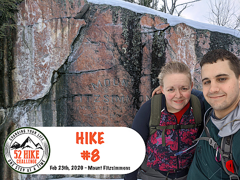
"In an unusual turn of events, there was no BHC hike planned on this sunny weekend.
But, I needed a hike for my goal of doing one "52 Hike Challenge" hike per week, and a friend of mine was determined to beat me in a weekend step count challenge (which at the time of writing he is doing despite this...), so my wife and I decided to go and answer a question I have long wanted to know since my Dad and I bushwhacked back in 2016 and discovered there were actually trail markers - where the heck is the trail?!
This hike resulted in discovering what we believe is the remains of a trail that is no longer maintained - we were able to get to the summit without any obstacles." — RangersApprentice • Feb 23, 2020
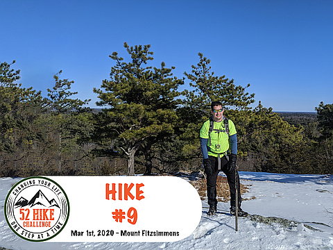
"Beautiful but cold Friday morning. I bushwhacked from the 401 near Fitzsimmons Road up to the peak. The snow wasn’t too deep and was packy enough for good traction. Great views , very peaceful with only the sounds of some winter birds. I grew up about 4km east of the mountain , so it is like a homecoming of sorts. " — kencirtwill • Feb 14, 2020
"Got off the proposed route and got mixed up. I did find some interesting trail junk and a deer hunting camp. I was running out of time and water, so I ditched the attempt st the summit. I've already done it a number of times. On the must have list.....A compass or GPS. : ). A bad area for ticks. Take precautions when you go. " — kencirtwill • Oct 14, 2019
"Bushwhacked our way to the Summit starting from 1,000 Islands KOA. Only to discover trail markers towards the summit. Couldn't find any information online of any marked trail. However, still and enjoyable hike and a good way to keep those map and compass skills fresh." — HikingViking • Feb 27, 2016
Awards
About peakery awards
Log successful summits on peakery to earn awards:
Peak Badges: Earn a special badge for each unique peak you summit. See all of your badges on your Badges page.

First Ascent Award: Only 1 available per peak. Goes to the first peakery member to log a successful summit of a peak. Snag this award and the peak will forever bear your name.

King of the Mountain Award: Only 1 available per peak. Summit a peak more times than any other member. Beware: this award can be lost!

Summit Steward: Summit a peak at least 5 times to become one of its Summit Stewards. As Steward of a peak, you’re encouraged to keep that peak’s info up-to-date on peakery and spread goodwill on your future climbs up the peak.