Highest peak
Kearsarge North
3,268 ft / 996 m
Most prominent peak
Kearsarge North
1,758 ft / 535 m prom
Most climbed peak
Kearsarge North
86 climbs
Most difficult peak
no info yet
Difficulty breakdown
no info yet
Highlights
Latest climbs
"Point to point from Passaconway rd to the Diana’s bath trailhead. Very on the ledge portions of trail and the snow was relatively packed on the forested sections. Warm day but very clear and beautiful!" — noahthackeray • Jan 10, 2026
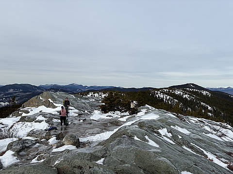
"Warmer day than forecasted, a little hot in the sun, with temperatures nearing 80. No clouds and no wind meant the bugs were brutal, even with bugspray applied. I set off from the trailhead around 10am. The first three-quarters of a mile are mildly sloped, with some sections essentially flat. Kearsarge Brook babbled to my right, but remained out of sight until the very end of the approach section. At this point, the trail turned slightly to the right and began getting steeper and rockier, although it was still moderately sloped. About a mile and a half in, the roots, rocks, and dirt gave way to large rock slabs. Shortly after, I emerged onto a series of rocky clearings which offered occasional views to the south. The trail returned to tree cover for the final ascent, which grew steadily steeper and rockier, although I didn’t need to scramble up any sections. The trail remains steep all the way to the summit. The summit offered spectacular 180-degree views to the southwest of Chocorua, the Moats, and Ossipees, but the real views are on the lookout tower. Although the tower is only one story tall, it clears the trees to the north, providing an unobstructed 360-degree outlook. Some cl..." — JCalautti • May 28, 2025

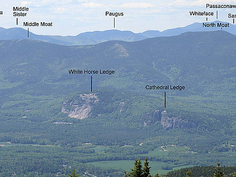
"Helping out Juel with her red-lining. We did a traverse over Attitash Tr. We went up the Bear Notch side. Chilly windy day today. Still some heavy cloud cover by the time we reached Table Mtn. We hit the true summit and the summit canister was gone. We touched a few bumps on Big Attitash Mtn then headed steeply down. We then went up the backside of Whitehorse Ledge for the nice views there, then down Bryce Path to the other car. " — newenglandwarrior • Sep 16, 2022

"The first part of this trail my son complained bitterly, took about 6 breaks, and was driving me nuts. He was better when we turned to hike over to Cranmore, as that trail was mostly flat or downhill. He had thankfully got it out of his system, and by the time we got back to Black Cap Trail he was willing to summit Black Cap too. It's a short distance from the junction with Cranmore Trail, so it would have been dumb to skip it. He didn't mind the more vigorous climb up and was rewarded with great views of the surrounding mountains and even the summit of Cranmore where we had been standing not long before. Despite it being a steamy day, it was a great day to hike. Hit up Zeb's in No Conway after, then the pool when we got home. In the words of a great philosopher, "today was a good day."" — mikewilliamsjr • Aug 30, 2022

"Great views of the Whites from atop the ski area. The Cranmore trail is basically all downhill from the junction at Black Cap Trail. It's weird to hike down to summit a mountain. The trail ends at a dirt access road, we turned onto that to get to the top. Views of nearby mountains and North Conway. We took a break on the deck at the lodge, even though it was closed. Hiking back to Black Cap was a bit more work, because it was uphill in reverse, but really so gradual that it wasn't a big deal. Nice little hike, and combined with Black Cap made for a reasonable amount of miles and time on the trail. " — mikewilliamsjr • Aug 30, 2022