The "1Kers". Official peak challenge of 1000 ft peaks in New Jersey from the New Jersey 1K Club. Perfect for day trips from NYC area. The New Jersey 1K Club "seeks to bring attention to the many hiking opportunities and challenges that the Garden State offers". See more at https://nj1k.org
Highest peak
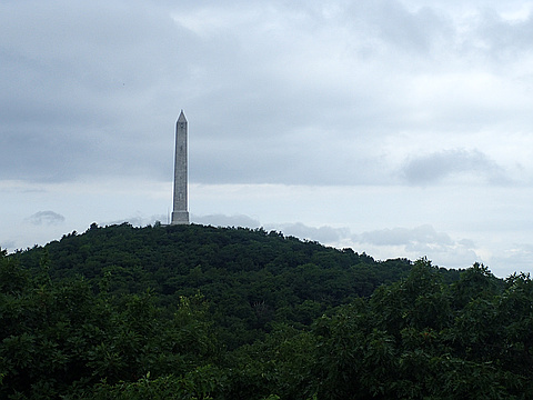
High Point (New Jersey)
1,803 ft / 549 m
Most prominent peak
High Point (New Jersey)
883 ft / 269 m prom
Most summited peak
High Point (New Jersey)
173 summits
Most difficult peak
no info yet
Difficulty breakdown
no info yet
Highlights
Latest summits

"Beth and I ran 12 miles in the morning then we were off to High Point, NJ to claim another state HP. We were supposed to bag Marcy this weekend but HS soccer got in the way. Jersey was the next best option. It was a 3 hours drive up to High Point State Park (with a lunch stop in Scranton, PA) - then we stretched our legs for a quick 3 mile hike around Monument Trail Loop to the High Point monument." — wiweasel • Sep 3, 2023

"Amazing hike to the summit of Mount Tammany. There were clouds under us and the views were excellent. After the summit we went down and took a different trail toward Sunfish Pond. Great Day!" — JONNYFL • Oct 15, 2022

"Perfect Autumn day for this HP. Traveled over from Delaware the day before. Number 18 for us in total. Parked at the bottom car park and walked up a quick half mile trail. Was very busy at the top as most people just drive up and park. A really nice monument was built there but closed on the day. Beautiful views all around." — CravinoCrew • Oct 23, 2021
"Started at Stony Lake and hiked Tower Trail up to AT, then AT along the ridge to Sunrise Mountain, took Blue Mountain connector down to Blue Mountain, to Tinsley, and from Tinsley hiked back to where I was staying.
Of note, I had an up close encounter with a porcupine just below the summit of Culver’s Ridge!" — bruno-osb • Oct 9, 2021
"This is actually a really nice set up . The park does a good job of landscaping and promoting the highpoint and there are a ton of activities to do in this area . Views into NJ, NY and Penn and excellent job on the informative signs about the rocks and history. Well done Jersey. There are 2 geodetic markers , one on each side of the obelisk." — puddlepirate • Jul 12, 2021