Region
Most climbed route
Highlights
- The highest point is at N43.739368 W72.137216, which is about 25 feet south of where the A.T. passes (to the right if NB). This is about 1/10 mile north of the southwesterly viewpoint spot where there is a small cairn, as described in the AMC White Mt. Hiking Guide
Latest summits

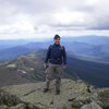
"I ascended Moose Mt. from the north side this time to finish off that A.T. section. The trail was a bit difficult to follow at times due to the lack of blazes along this section. When I reached the snowy top I looked around again to see just where the actual summit is. In the process of taking multiple gps/altimeter readings, it appears that the highest point is at N43.739368 W72.137216, which is about 25 feet south of where the A.T. passes (to the right if NB). This is about 1/10 mile north of the southwesterly viewpoint spot where there is a small cairn. After chatting with some other hikers that came by, I returned back down to my car." — SteveM_StickMan • Apr 29, 2020

"A. T. section day hike on this beautiful spring day. I spent some time exploring this area, including the other "peak" of the same height 1/2 mile north (the knob next to the "T in Forest" on the topo map). It appears from the gps readings I took that a spot in this other area is slightly higher (about 5 ft) than the main peak location listed, which is the area that the AMC White Mt. Guide describes as the true peak. I plan on hiking up from the north side in the near future to do some more exploring of that possibility." — SteveM_StickMan • Apr 19, 2020

"04MAR2012: Hiked this in the foot of snow from Tuesdays Storm w/ a crust on top from Saturdays Rain. Was a nice climb. Took a lil' over an hour. The actual summit was treed in, but many view points along the way from the old ski slopes that used to be on the Mountain. Saw some abandoned ski lift structures as well. Also wildlife tracks were a plenty. Hike down was a bit easier. Some snowmobilers made a trek to the top for a looksee, and I was able to walk their packed trail down. " — CiccheMariti • Mar 4, 2012
"Part of my 12-mile loop. I never knew the moment I actually reached this summit. At one point I noticed that there didn't seem to be any more elevation to gain out ahead of me, so the summit must be behind me somewhere." — GSDTheFlea • May 14, 2011
Awards
Challenges
About peakery awards
Log successful summits on peakery to earn awards:
Peak Badges: Earn a special badge for each unique peak you summit. See all of your badges on your Badges page.

First Ascent Award: Only 1 available per peak. Goes to the first peakery member to log a successful summit of a peak. Snag this award and the peak will forever bear your name.

King of the Mountain Award: Only 1 available per peak. Summit a peak more times than any other member. Beware: this award can be lost!

Summit Steward: Summit a peak at least 5 times to become one of its Summit Stewards. As Steward of a peak, you’re encouraged to keep that peak’s info up-to-date on peakery and spread goodwill on your future climbs up the peak.