Highest peak
Radziejowa
4,156 ft / 1,266 m
Most prominent peak
Skrzyczne
1,919 ft / 584 m prom
Most climbed peak
Wielka Racza
41 climbs
Most difficult peak
Radziejowa
Class 1
Difficulty breakdown
Class 1/2 10 peaks
Highlights
Latest climbs
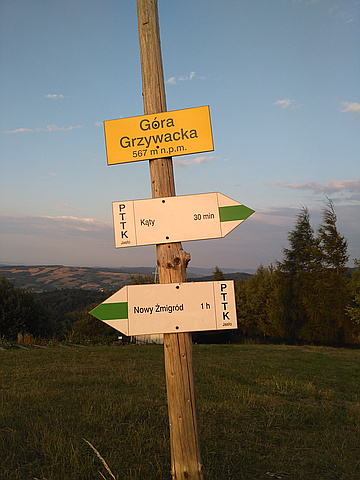
"Wyprawa geocachingowa. Wieczorem 20 lipca 2019 roku postanowiłem zrobić krótką trasę zielonym szlakiem z Kątów przez Górę Grzywacką, potem zgodnie z drogą krzyżową wrócić do drogi. Choć był to słoneczny dzień, to jednak o tej, dość późnej godzinie bezsensownie wybrałem się jedynie w t-shircie, więc po drodze zmarzłem. Gdy dotarłem do szosy byłem już pewien, że złapię przeziębienie." — haudek • Jul 20, 2019

"Together with 4 of my friends did a 30km walk around Gorce. We started in Rzeki and we took blue trail south to Gorc peak. Next we turned west to Turbacz peak following green trail. Walking back to car we decided to take the yellow trail that leads through Kudłoń and Gorc Troszacki. The whole trip took us almost 10 hours." — szymonkodrebski • Apr 14, 2018

"An outing during a stay in Wrocław. We parked in the large car park at Prz. Walimowska (10 złoty). Beginning on the black trail round the north flank of the mountain, we diverted onto a higher forest track that met the yellow trail up the west ridge via Mała Sowa. This was steep at first but soon leveled off along the ridge, with opening views through the forest of beech, firs and bilberry. A short pull brought us onto the cluttered summit area. We then climbed the 25m observation tower (6 złoty each) to view the fine, if hazy, panorama. To descend, we followed the yellow trail west for several hundred metres, then taking the blue trail north back to the car park. Hazy sunshine, clouding over more later. Strong south-east wind. Spotted Vanessa atalanta, Aglais urticae and Pararge aegeria butterflies in a forest clearing as we descended. " — marktrengove • Aug 4, 2017
"I started my hike at 7:00AM in Wilkowice from Zywiecka street where the red trail begins and leads straight to Magurka top. At that point red trail connects with blue which leads to Czupel top. I followed the blue trail and I reached the top at around 9:30AM." — szymonkodrebski • Feb 12, 2017

"Along green and blue trail. Start in Zalesie, finish in Szczawa. Light snowfall all the time, poor visibility and in places more than 50 cm of fresh snow. 550m gain and 650m lost. Good hike." — JakubW • Jan 16, 2016