Most climbed route
Highlights
Routes
/-83.1506866455078,35.4506642331195,11,0.00,0.00/320x240@2x?access_token=pk.eyJ1IjoicGVha2VyeSIsImEiOiJjampra3Z0bnAxeTVnM3FteHlybHY3b2p1In0.7a5dEa5-995VUv8ceHHNmw)
1 summit • 3.0 mi • 369 ft gain • 2 hr 7 min • Class 1
1 summit • 5.1 mi • 1,023 ft gain • 4 hr 41 min
1 summit • 7.2 mi • 3,609 ft gain • 6 hr 5 min
Latest summits

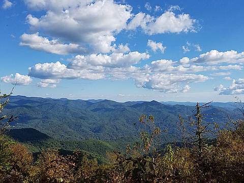
"Drove Blue Ridge Parkway to Waterrock Knob parking, then hiked back down to and across Blue Ridge Parkway to ridge trail to Yellow Face peak and back. Gina made it up the steepest section to the best overlook. The trail goes over a small peak then gets steep on the final ascent to Yellow Face peak. For my 6-foot frame it was a class 1 with trekking poles, but Gina had to scramble a few places with her 5-foot frame. Some sections are narrow with overgrowth, but poles were sufficient to hold back a few briars. Past the peak gets tight with overgrowth. A sign near the trailhead says it is 0.6 mile to Yellow Face, and I suspect my noisy GPS/GPX recording is responsible for the extra miles totaled. The trail is not as straight as indicated on the maps, but it is not as crooked as indicated by the noisy signal." — davidensley • Jul 23, 2022

"It was quite foggy and there were scattered showers through this short hike. I parked on the side of the road, at the entrance of the Waterrock Knob parking lot. Across the street and to the right, there is a trail coming out of the woods. There is a box and a sign with distances to each destination. Yellow Face is just .6 miles away.
The first two thirds of the trail were rather easy. Meandering through the Forrest and small balds with (fog obstructed) views along the way.
The last portion is a bit more difficult. The rock face is quite slippery in the rain. The trail becomes steeper as you near the top. However, the dogs had no issue with the climb.
The summit is up on an open field, and it should make for great views if there aren’t clouds all surrounding you. " — ChrisM • Apr 24, 2018
"Double in-and-out day hike comprised of five Southern Sixers in the Plott Balsams. Aside from the crowded short trail up to Waterrock Knob, I encountered no other hikers for the rest of the day (I had the summit to myself in the morning, when I returned in the afternoon it was packed with tourists). I was somewhat concerned about having to bushwhack several miles out to Plott Balsam, but was happy to find that trail, while rugged, was generally clear and easy to follow. Outstanding views to be had on Waterrock Knob, Browning Knob, and Mt. Lyn Lowry.
Waterrock Knob Visitor Center > Waterrock Knob > Browning Knob > Mt. Lyn Lowry > Oldfield Top > Plott Balsam > Waterrock Knob Visitor Center > Yellow Face
Total Distance: 11.58 mi.
Altitude Gain: 3689 ft." — WGMayo • Sep 24, 2016
Photos
Awards
Challenges
About peakery awards
Log successful summits on peakery to earn awards:
Peak Badges: Earn a special badge for each unique peak you summit. See all of your badges on your Badges page.

First Ascent Award: Only 1 available per peak. Goes to the first peakery member to log a successful summit of a peak. Snag this award and the peak will forever bear your name.

King of the Mountain Award: Only 1 available per peak. Summit a peak more times than any other member. Beware: this award can be lost!

Summit Steward: Summit a peak at least 5 times to become one of its Summit Stewards. As Steward of a peak, you’re encouraged to keep that peak’s info up-to-date on peakery and spread goodwill on your future climbs up the peak.