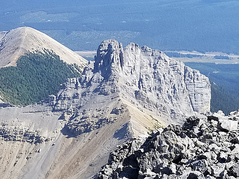
Region
Highlights
Routes
/-115.371465682983,50.8134735646603,11,0.00,0.00/320x240@2x?access_token=pk.eyJ1IjoicGVha2VyeSIsImEiOiJjampra3Z0bnAxeTVnM3FteHlybHY3b2p1In0.7a5dEa5-995VUv8ceHHNmw)
6 summits • 19.2 km • 1,872 m gain • 7 hr 26 min
2 summits • 14.8 km • 928 m gain • 6 hr 32 min
1 summit • 11.7 km • 469 m gain • 5 hr 6 min
1 summit • 13.7 km • 869 m gain • 8 hr 30 min
Latest summits

"While going down the scree I noticed a nice trail traversing the slope. I decided to follow it as it was quite nice looking and easy to follow most of the time. It traversed the slopes and took me around to the trail on the ridge above Tryst lake and then down to the lake and out." — Randy • Aug 11, 2022

"I was able to connect with Simon as this was on his list too and we both took an afternoon off work during the week as it's a bit shorter a scramble. The in was easy, the bushwhack up the gully wasn't too bad and then the scrambling began. We had good teamwork. Simon is better at the exposure and I was a bit better at the climbing around the chockstones so we helped each other out. It's best to be the only party on the route at any given time and to keep it small. You do not want others around you for this and you have to be careful for each other as the gully is narrow and it's hard to get out of the way and find a place to not knock down even small rocks. Instead of retracing the easier uptrack, we took the super scree down and opted for the tighter bushwhack to the trail. Bugs sucked but no bear, so that's good!" — leigh-annewebster • Jul 8, 2021

"Interesting scramble. It used to be on the easier side of "difficult" via the famous chimney. In the recent years, 2 chockstones made it much more challenging. It took me a great deal of efforts (and some aerial acrobatics a-la Jean Claude van Damme) to climb over the chockstones on the way up and down, although taller people would have less trouble. The other route, on the right side of the fin, is probably easier but I didn't try it.
On the way up, I traversed from Tent Ridge. Not recommended even though this route is shorter. It's a nasty side-slopping on the very loose rubble. I was very cautious and slow. Still, at one point, I triggered a sizeable rock slide and watched it go for over 2 minutes. I sighed in relief once I joined the normal route. The Kane standard route is much nicer. " — Taras • Sep 3, 2017
"CSMC Trip (Smuts, The Fist, Tent Ridge) 13 hr 27 km 2000m and 2 km bushwack. Descended back to Commonwealth Creek and re-ascended to The Fist. Loose chimney no where near as good as Smuts. Quick 1 hr ascent from col and then went north to Tent Ridge." — alexjoseph • Sep 2, 2017

"Afterwork scrambling with CSMC. Rainy start but it dried up quickly. Got back down to the valley with some light, and used a headlamp to walk out from there. 6 hrs car to car. Not bad for four people." — BertB • Jun 8, 2016
Photos
Awards
Challenges
About peakery awards
Log successful summits on peakery to earn awards:
Peak Badges: Earn a special badge for each unique peak you summit. See all of your badges on your Badges page.

First Ascent Award: Only 1 available per peak. Goes to the first peakery member to log a successful summit of a peak. Snag this award and the peak will forever bear your name.

King of the Mountain Award: Only 1 available per peak. Summit a peak more times than any other member. Beware: this award can be lost!

Summit Steward: Summit a peak at least 5 times to become one of its Summit Stewards. As Steward of a peak, you’re encouraged to keep that peak’s info up-to-date on peakery and spread goodwill on your future climbs up the peak.