Region
Highlights
Routes
/-122.008237838746,47.4992712255643,11,0.00,0.00/320x240@2x?access_token=pk.eyJ1IjoicGVha2VyeSIsImEiOiJjampra3Z0bnAxeTVnM3FteHlybHY3b2p1In0.7a5dEa5-995VUv8ceHHNmw)
17 summits • 4.1 mi • 1,592 ft gain • 3 hr 0 min
9 summits • 6.8 mi • 1,869 ft gain • 3 hr 10 min
6 summits • 4.2 mi • 1,592 ft gain • 1 hr 29 min
2 summits • 7.3 mi • 1,630 ft gain • 2 hr 40 min
2 summits • 6.6 mi • 1,565 ft gain • 2 hr 52 min
1 summit • 7.4 mi • 1,621 ft gain • 3 hr 2 min
1 summit • 10.5 mi • 2,884 ft gain • 2 hr 46 min
1 summit • 10.6 mi • 2,715 ft gain • 2 hr 9 min
1 summit • 11.1 mi • 2,603 ft gain • 2 hr 49 min
1 summit • 12.5 mi • 3,292 ft gain • 4 hr 10 min
1 summit • 13.4 mi • 3,238 ft gain • 5 hr 44 min
1 summit • 15.7 mi • 3,118 ft gain • 5 hr 59 min
1 summit • 16.9 mi • 3,169 ft gain • 3 hr 49 min
1 summit • 17.6 mi • 4,535 ft gain • 4 hr 55 min
1 summit • 33.5 mi • 5,555 ft gain • 8 hr 45 min
1 summit • 9.6 mi • 2,697 ft gain • 2 hr 24 min
1 summit • 9.8 mi • 2,437 ft gain • 3 hr 18 min
1 summit • 11.6 mi • 2,620 ft gain • 7 hr 8 min
Latest summits

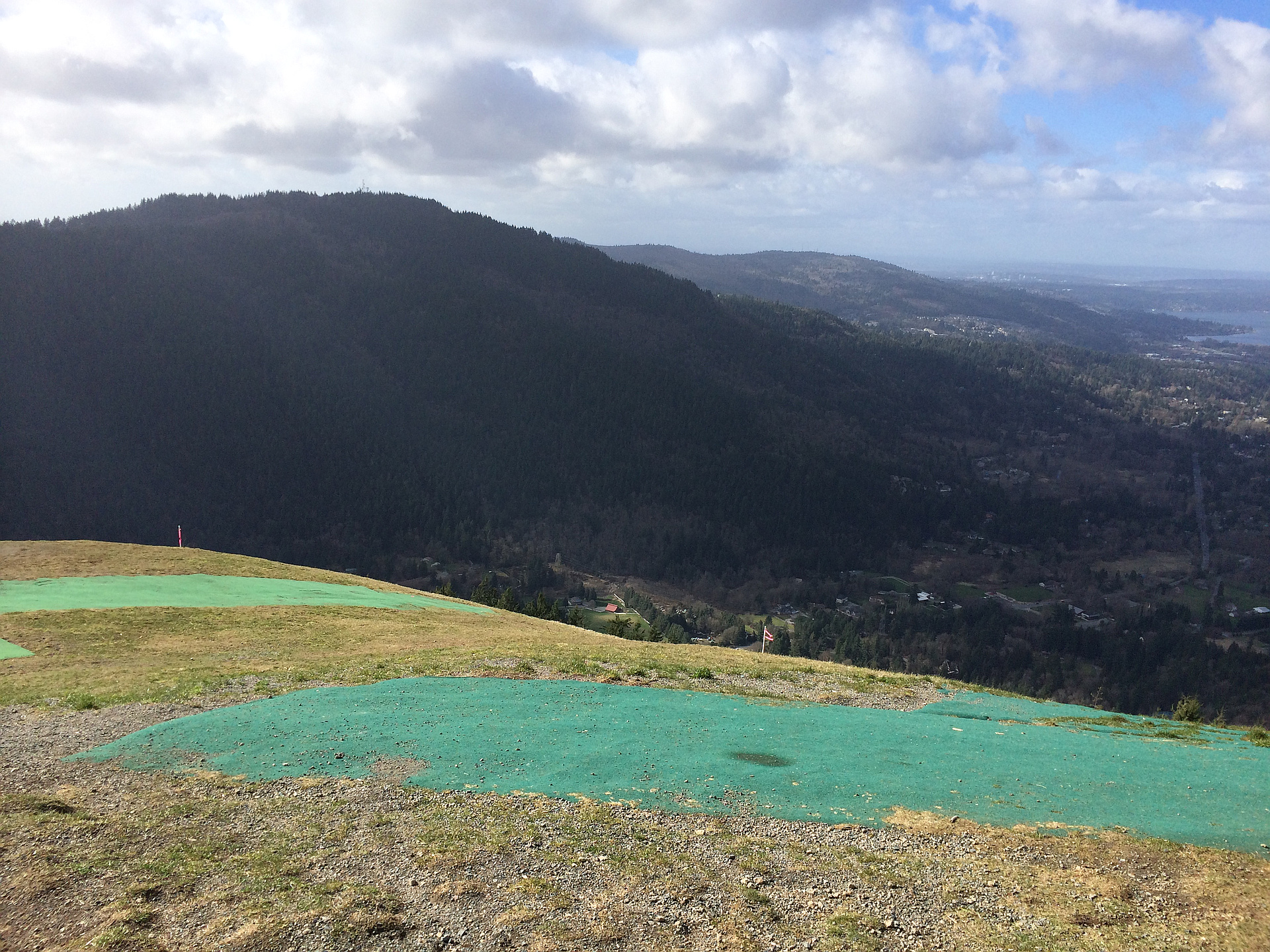
"I started at High School Trailhead and followed it to the Poo Poo Point Trail. It's less popular than the Chirico trail that leads to the same point, but it is still well traveled and maintained. The incline is steady and not technical at all, so novices should expect their heart rates to go up without too much strain." — IanW • Aug 7, 2020

"Took a quick trip after work to Poo Poo Point via the High School Trailhead. Normally I would poo poo Poo Poo Point as its on Tiger Mountain and a high trafficked trail I assumed is used mostly by Issaquah High School students for training, however I discovered the Issaquah Alps Peak Challenge - 24 summits spread among Cougar, Squak, and Tiger Mountains, and this is on the list. The route, once past the utility right of ways is actually a beautiful trail, up through the forest and ridge with lush sword ferns, devil's glove, salmonberries, and the typical flora of the area. On the upper reaches of the ridge, the trees thin our providing beautiful views through the area. The view from PPP is amazing and it was so cool to see so many hang gliders out today. Highly recommend this route for a good shortish hike with decent gain and great scenery. I was surprised to see how much water was flowing through Gap Creek as we crossed the bridge. I am curious as to the source of the water in this part of summer. This hike exceeded expectations and I would highly recommend it." — markhadland • Aug 4, 2020

"I chose Poo Poo Point as a short end-of-day hike to break in and try out my brand new boots! They are great, Asolo TPS, some brand from Romania. Ran into a dozen people on the trail; one group was going up at dusk with flashlights. This may have been the last day of the great summer weather; rain starts tomorrow for at least a week! 1600 ft gain, 3.6 miles, 2:15 hours." — markgarrett • Oct 3, 2016

"We went with Nikhil, parked near the High School on the staff parking, and all the way up I was afraid that it'll end up getting towed. But the hike was very nice. And the car didn't get towed, lucky." — mospehraict • Jun 29, 2014

"The throes of Thursday, or "what more can we do to recklessly plummet to the deepest clinical depression?"
In the sweet spirit of self-inflicted suffering, I took my oldest son on an adventure through the West Tiger mountains yesterday for a delightful celebration of Mother Nature.
First, we kicked it off with a sunrise trailhead launch: 6:30 am. En route to the park I could feel him thanking me for that little treat. What better way for a young man to enjoy Spring Break as it eased into it’s last days?
Along the way we enjoyed 13 miles of torturously boring trails as we launch headlong into the redundancy of forest views coupled with more forest views. We bathed in lifeless moss, canker, decay and periodic toxic putrefaction while celebrating our journey bagging 4 “peaks” of the famed and utterly deflating Issaquah Alps. Not only were we rewarded with yet more forest views when reaching each peak, but we found ourselves surrounded and cooked by the inspiring magnificence and RF radiation of cell towers and microwave antennae. In the uncommon case that we did encounter a view, the territorial awe and nausea found in Urban sprawl met our lowest expectations. We even r..." — herdingcats • Apr 10, 2014

"We approached from the Poo Poo Point trail as it was getting dark after hiking all over the mountain and having never been here before missed the Chirico Trail which was the planned route down. We walked a little ways on the gravel road past the Chirico Trail before we became sure we had missed the trail. By the time we were actually on the Chirico Trail it was completely dark making for an interesting descent." — Al-Rashid • Oct 16, 2010
Photos
Awards
Challenges
About peakery awards
Log successful summits on peakery to earn awards:
Peak Badges: Earn a special badge for each unique peak you summit. See all of your badges on your Badges page.

First Ascent Award: Only 1 available per peak. Goes to the first peakery member to log a successful summit of a peak. Snag this award and the peak will forever bear your name.

King of the Mountain Award: Only 1 available per peak. Summit a peak more times than any other member. Beware: this award can be lost!

Summit Steward: Summit a peak at least 5 times to become one of its Summit Stewards. As Steward of a peak, you’re encouraged to keep that peak’s info up-to-date on peakery and spread goodwill on your future climbs up the peak.