Mimaropa peaks
Mimaropa summits
First Ascent Awards
20 of 301 peaks 6%
Top climbing months
April 31%
June 14%
May 14%
Top ranges
no info yet
Mimaropa mountains highlights
Latest summits
"Took me 4 hours and 15 mins to reach the summit. The trail to the top is a continuous steep climb. Wont recommend it to novice climbers or those who have not prepared physically and emotionally.
It was a 2-hour descent from the peak.
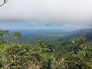
When i was at the peak, i posted this on my FB wall (yup, there was Smart signal at the peak, Smart coverage was not lost during my assault of the summit): "To my North stands Mt Gantung; to the West is the majestic Mt Mantalingajan whose flat summit is obscured by cumulus clouds. On the west is a vast spread of water called Sulu Sea. I can see San Antonio Bay, the parts of which are hidden by Mt Malis; the Tinangisan Sandbar is glimmering from here. The road leading to Rio Tuba is very visible. Meanwhile, the townproper of Brookes Pt which unfortunately i can barely have a sight of is on the east; shrubs and trees have grown to heights which prevent me to have a view of it."
" — EyomSadongdong • May 25, 2014

"It was a success. My 2nd clearing streak! We got a nice weather... awesome clearing with a full view of the saw-toothed peaks from sunrise to sundown! videolink: http://www.youtube.com/watch?feature=share&v=yuZ9RMBq3Go&app=desktop" — gerryrementilla • Apr 20, 2014

"3 hrs of very steep (90%-80 degrees ascent) rock scrambling, loose rocks and ferrata-like trail.Not ideal for first time-climbers. The Mountain can be considered a very difficult climb and needs a lot of upper body strength and endurance. Its Ferrata Trail has 30-40% deep slopes with loose rocks.. The traverse was much easier with well established trail that took 1 hr and 20 mins to descent.
" — franklin-acepanuncio • Jun 11, 2012

"I took the ascent to Mt Mantaling from Barangay Bono Bono, Bataraza on May 25, 2012. I had with me a tribal chieftain, a brusher, a tribal medic to guide and help me climb up Mantaling and then do a cross-country to Rizal, Palawan. We slept in tribal villages for 2 nights. Chieftain Betilo took pride going up the mountains with me and introducing me to the tribesmen including the Taut Batu's who live along the trail going to Rizal.
Saw a tree house made by the indigenous people a few meters from the peak of Mantaling. :)
At the peak, facing north, i could marvel at the majesty of the highest mountain in Palawan - Mt Mantalingajan. On the east, i had a view of San Antonio Bay and the vast span of Sulu Sea. Facing South, I could see Mt Marinsyawon, Mt Arib and even the Tres Marias which is slightly hidden by Arib, and the imposing mountain in my village, Mt Bulanjao.
I felt closer to heaven and thought of not leaving the peak... but I had to. " — EyomSadongdong • May 27, 2012

"this was my 1st attempt to climb a mountain. i took an old already unmarked shortcut so i was able to reach the top in less than an hour. the view at the top was breathtaking." — tzitech • Jun 1, 2011