Region
Highlights
Routes
/-117.490151,33.629322,11,0.00,0.00/320x240@2x?access_token=pk.eyJ1IjoicGVha2VyeSIsImEiOiJjampra3Z0bnAxeTVnM3FteHlybHY3b2p1In0.7a5dEa5-995VUv8ceHHNmw)
4 summits • 10.4 mi • 2,043 ft gain • 6 hr 4 min
1 summit • 11.0 mi • 1,759 ft gain • 5 hr 36 min
Latest summits

"Started at the San Juan Trailhead next to Blue Jay Campground. I climbed New Sugarloaf first by utilizing a summit use trail. Old Sugarloaf was definitely more difficult. I managed to fit it in before the threatening clouds began dropping rain." — MikeTeeples • Oct 1, 2023

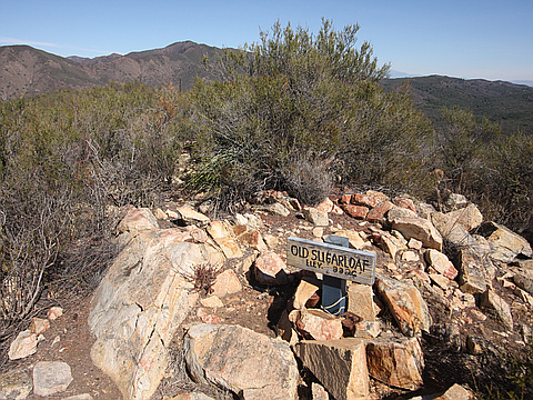
"We started on this hike at 7 AM at the Hotsprings Trailhead. Then we ascended some long switchbacks with great views of Los Pinos Peak. Then the trail had really great views. There is some shade along the way. Then there were some more risky switchbacks. Then we saw our first views of the summit of Old Sugarloaf. Then we summited Old Sugarloaf and got excellent views from Old Sugarloaf. There is a small register tin and a summit sign on the top of Old Sugarloaf. We then rested at the only trail on the trail, then summited New Sugarloaf. There was a cool Split Rock near the summit. The summit has 2 signs, some okay views, and a register tin.
" — lc444 • Aug 8, 2022

"Started out from Hot Springs trailhead and hiked up the San Juan trail to bag Old Sugarloaf and Sugarloaf. Great gradual incline trail, other than the use trails up to the two summits. Crummy weather led to wet undergarments (TMI LOL). Ran back down the trail to stay warm. " — danishclimber • May 16, 2021
"The Old San Juan Trail took me to the base of Old Sugarloaf from Sugarloaf Peak. The use trail had a little more grand entrance than Sugarloaf (Two ducks instead of a pile of rocks). Old Sugarloaf loomed rather high over head, and it proved to be as difficult as it looked, being a rather steep climb to reach the summit. I again hung around to sign the register and take a few pictures. The peak conquests were over, but I had to spend the rest of the afternoon climbing uphill back to the trail-head in the heat. This part of the hike wasn't as much fun as climbing the peaks." — MikeTeeples • Nov 3, 2018

"The Beast - I joined up with some friends from the hiking group 3H (Hiking For Health and Happiness) to do there annual "La Bestia" hike. This hike took us to five peaks, 2 campgrounds (one where we bbq'd), 29.2 miles and almost 8,000 feet in elevation gain. Wow! What hike with some great people. The leads for this group knew what they were doing and took care and responsibility for everyone on the trail." — Philip-Yoho • Dec 16, 2017

"I hiked Old Sugarloaf and Sugarloaf on a very cloudy, misty, drizzly day. I could not even see the summit of Old Sugarloaf until I was at the summit due to the clouds and fog! I hiked from Blue Jay Campground along the Middle San Juan Trail thinking it was the more direct Old San Juan. I passed and missed Sugarloaf! I misread the junction with the Old San Juan Trail near mile 5, where I should have made a right for 150 yards to a use trail. I then continued hoping to find Old Sugarloaf's use trail, and missed it too! I passed the 6 mi. mark along San Juan, then tried hiking up cross-country up a ridge I thought may be Old Sugarloaf, then turned back, then backtracked the San Juan Trail and finally found a small cairn and narrow trail I missed the first time. I knew this was the right way to one of the two summits, but I did know at the time whether it was Old Sugarloaf or Sugarloaf. I determined that the elevation gain up the extremely steep use path was leading up Old Sugarloaf, which is 600'-700' straight up! I was right when I hit the old wooden sign on the peak! I descended and eventually found the use trail to Sugarloaf as well and the climb was shorter, but class 2..." — brianpowell • Oct 20, 2017
.JPG)
"Got this peak and Old Sugarloaf in the same hike. Started at the Old San Juan trail head at Blue Jay Camp. Hike was 11.4 miles total. It started off descending into a mostly shaded canyon before rising toward the two hills. There are several smaller unmarked trails that intersect, but it is pretty easy to stay on the main trail. The use trail to the Sugarloaf peak is easy to see from the main trail and has a small cairn marking the start. It is slightly overgrown in places and I was glad I was wearing pants even though it was going to be a hot day. The last bit of the "trail" consists of climbing boulders where I had to use my hands in several places, but not too difficult. Signed the peak log at the top, but did not find any markers. Next was Old Sugarloaf. It's use trail was harder to spot and easy to miss. It is on the right side of the trail and has a small cairn (I added a few more rocks to it). Once you find the trail, it is easy to follow to the top, but the trail is very steep with lots of loose rocks. It is also narrow and was glad again that I wore the pants legs to my convertible pants. Like Sugarloaf, there was a peak log, but no markers. Returned the same way with the ..." — aaronm • Jul 26, 2015

"1.3 mile w/700' gain (and 600' loss) from nearby Sugarloaf Peak on Old San Juan Trail and peak trail. My 1st ascent of Old Sugarloaf w/ Denise A and Steve W. 5.2 mile descent to Blue Jay CG TH. " — BradStemm • Feb 6, 2012
Photos
Awards
Challenges
About peakery awards
Log successful summits on peakery to earn awards:
Peak Badges: Earn a special badge for each unique peak you summit. See all of your badges on your Badges page.

First Ascent Award: Only 1 available per peak. Goes to the first peakery member to log a successful summit of a peak. Snag this award and the peak will forever bear your name.

King of the Mountain Award: Only 1 available per peak. Summit a peak more times than any other member. Beware: this award can be lost!

Summit Steward: Summit a peak at least 5 times to become one of its Summit Stewards. As Steward of a peak, you’re encouraged to keep that peak’s info up-to-date on peakery and spread goodwill on your future climbs up the peak.