Most climbed route
Highlights
Routes
/-83.50601299530733,35.56216144487736,11,0.00,0.00/320x240@2x?access_token=pk.eyJ1IjoicGVha2VyeSIsImEiOiJjampra3Z0bnAxeTVnM3FteHlybHY3b2p1In0.7a5dEa5-995VUv8ceHHNmw)
1 summit • 23.8 mi • 4,016 ft gain • 10 hr 39 min
1 summit • 3.6 mi • 711 ft gain • 2 hr 15 min
1 summit • 5.7 mi • 1,112 ft gain • 2 hr 29 min
1 summit • 8.0 mi • 827 ft gain • 3 hr 5 min
Latest summits

"“Rest day” today. 🤣 Drove out to Clingman’s Dome road in SMNP. Hiked the icy paved trail up to the observation tower with hundreds of folks. Picked up the AT to head down via Mount Buckley and snagged Andrew’s Bald before hitting the Clingman’s visitor center and motoring up to Pigeon Forge to catch Dolly Parton’s Stampede." — wiweasel • Nov 23, 2023
"Purchased and printed GSMNP parking permit before departure using link at GSMNP Challenge. Arrived at noon with plenty of parking available. Gina and I hiked the bypass trail to the AT to Mount Buckley then to Clingmans Dome and the asphalt trail back to the parking lot. On the bypass trail I worked slowly through elevation sickness around 6400 ft without having to go back down." — davidensley • Apr 24, 2023

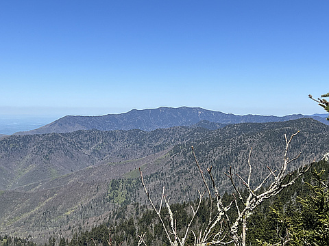
"Mt. Buckley was a much easier side trip along the A.T. southbound from Clingmans Dome (150' less elevation drop). As along the northbound section, there were only a few lookout points. This side of the A.T. also was a bridle path in years past, following the state line between North Carolina and Tennessee for quite a distance. Met some through hikers along the way on this side. The parking lot was understandably packed by the time I left, around 11am. On to Mt. Mitchell!" — SteveM_StickMan • Jun 26, 2020

"We started from the Clingmans Dome parking lot and took the Forney Ridge Trail to the Clingmans Dome Bypass Trail to the AT, heading west to summit Mount Buckley. We then headed east on the AT to summit Mount Love, then back to summit Clingmans Dome and back to the parking lot for a three peak summit circumnavigation." — marshallstewart • May 18, 2014
Photos
Awards
Challenges
About peakery awards
Log successful summits on peakery to earn awards:
Peak Badges: Earn a special badge for each unique peak you summit. See all of your badges on your Badges page.

First Ascent Award: Only 1 available per peak. Goes to the first peakery member to log a successful summit of a peak. Snag this award and the peak will forever bear your name.

King of the Mountain Award: Only 1 available per peak. Summit a peak more times than any other member. Beware: this award can be lost!

Summit Steward: Summit a peak at least 5 times to become one of its Summit Stewards. As Steward of a peak, you’re encouraged to keep that peak’s info up-to-date on peakery and spread goodwill on your future climbs up the peak.