no info yet
no info yet
no info yet
no info yet
We threaded the needle. I met up with two of my friends, Pete and Scott, in Hood River on Tuesday evening July 19th. They rolled in from Seattle while I was staying with my family in Hood River for the week. The weather had been total crap all week long and despite it being July, it looked to be sheer Armageddon on Adams from the view (or lack of it) I had from Hood River. The reports said freezing and snow above 11,000 feet.
I had scoured the internet for any up-to-date accounts of climbs of Adams in the previous day or two and found only one report of someone who turned back because of white out.
One of my buddies, Pete, though an accomplished alpine skier who spends his winters at Squaw Valley, had precious little backcountry experience and brought his alpine ski boots for the climb and ski. I grimaced imagining his feet at day’s end. But then again, I didn’t expect him to make it very far out of the parking lot. Given everything, I didn’t think we had much shot of summiting and imagined the snow would be bulletproof anyway. Until 2 pm the day before I was about to pull the plug, but as I wavered on the phone with my friend Scott in Seattle, he said, “You realize this is my Grand Teton.” That settled it. Two years ago before the birth of my son, Scott and I had flown to Jackson to climb the Grand together in a last ditch effort to get my adventure fix before I went into full-on child-rearing mode. Now with Scott’s first child due in November, his words had their intended effect. The trip was on.
We left Hood River at 3:30 am Wednesday morning with a mostly starry sky. The weather called for 30% chance of snow after 11 am, so we figured we would move as quickly as possible. I was planning on a 1 hour 15 minute drive to the trailhead, which would be the first of our miscalculations of the day. We forgot to bring the book with the directions to the trailhead, and though I remembered them (from Trout Lake, take 80, then 8040, then 500), Scott assured me we should use google maps on our iPhones. Google maps authors were undoubtedly crying with laughter as we drove through horse trails and rutted out logging trails getting lost on our circuitous route there. We ended up at the trail head at 5:45.
The road was clear to the trailhead and there were many cars and tents in the parking lot. We had a quick set up and were hiking by 6:25 am. We had foregone the topo map because they were sold out of them in Hood River and we were planning on hiking and skiing the South Spur route, so didn’t imagine we would get too lost. And we had Scott’s GPS….
Since the South Spur route sounds straightforward aside from the effort factor, there had been some discussion about skiing the Southwest Chute to mix it up a bit. I had read that we needed to “stay high left” coming out of the chute so as not to end up in Morrison Creek drainage, so had some “pretty good beta,” and we had a GPS and we were pretty sure we would ski the South Spur route anyway. But we would leave that decision for later.
There was patchy hard snow at the trailhead at 5600 feet, but not skiable yet. Though we could likely have skinned starting at around 6,000 feet, we kept boots on and continued to hike as the suncups and runnels were all frozen and skinning wouldn’t have been easy. Pete was ambling along in his tennis shoes with his alpine ski boots hanging from his pack.
The sun was coming out and the views of Hood and St Helens were crystal. There were many ways up after about 7,000 feet, all of which were easy to visualize and there were many other climbers out. We had to traverse rock a few times, and by about 7500 feet we were skinning.
The sun was out in full force aside from some clouds slowly encroaching on our day. The snow softened up beautifully, and by 10:30 we were eating lunch and resting at lunch counter at 9200 feet. Though we had been talking and telling stories and feeling strong earlier in the morning, there were now mutterings about getting to Piker’s Peak and re-assessing our general state. Having spent a week in the Eastern Sierras earlier this Spring where I ended up turning back off some summits because of fatigue/altitude, I was loathe to consider turning back before the summit. But we were all starting to move slowly.
Looking up at the false summit of Piker’s Peak does not do much to reinvigorate the weary. It is a slog of nearly 2,000 vertical feet straight up from Lunch Counter. While the pitch looks perfect for skiing down, the skinning or booting up looks interminable from Lunch Counter.
We started off again at 11 am. Clouds were drawing up alongside the mountain. Across the Gorge we could see the middle slopes of Hood being enveloped in clouds. I felt the urgency of time and the weather, and was starting to get my second wind. As I approached the false summit, I switched from skins to boots and found a better rhythm. The snow quality was great and had softened up significantly. Scott and Pete were nearly 30-45 minutes back at this point, so I continued on to the summit, imagining they would call it a day at Piker’s Peak.
I booted the rest of the way from Piker’s Peak to the summit in about 45 minutes, summiting in the sun at 1:45. It was windy and cold, so I snapped some photos and chatted with another skier from Portland. He said he and his friend were planning on skiing the Southwest Chutes as well, so I figured we might tag along, as they had a GPS and a topo map. I started skiing down and met Pete and Scott half way up the summit face. Though haggard, they were soldering on and intent on completing the climb. I waited for them and tried to make note of where the other two climbers skied into the Southwest Chutes.
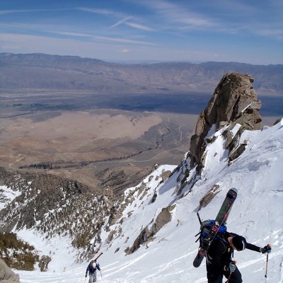
Pete and Scott finally skied down to me around 3:30 and we headed over towards the Southwest Chutes. Scott asked me for some water as he and Pete had finished theirs about 2/3rds of the way up. I too was out of water, but we had simply to ski out now, so it wouldn’t be too long. We looked into the entry where the other skiers had skied, but I was concerned it would drop us out too far West, so we continued south along the ridge until we found our line, which I think was the true Southwest Chute. High clouds had moved in and the snow on the summit face which had been corn for me had started hardening. I was worried we had missed our window. But as we dropped in, we were treated to perfect corn for the full 3,000 + vertical feet the chute provides. It is a very manageable slope at about 35 degrees. It was effortless skiing and a huge payoff for the day’s effort.
I turned to Pete midway down and said, “I don’t want to jinx us before we’re all the way out, but we nailed it today. We all summitted, we hit the one good day of gorgeous weather in a week of storms and here we are skiing great corn on July 20th on the Southwest Chutes.” We continued to the bottom of the chute and then assessed our way out. Scott’s GPS was caput, he said…
I remember reading that we were supposed to “traverse high and left” at the bottom of the chute, but this seemed to run us up against rock, so after 10 minutes of deliberation, we followed many other ski tracks out through the valley of runnels. We continued to descend making sure to keep and eye out for the high traverse East, but it was much too late. We eventually ran into the two other skiers who had also come down the West side, and they told us we were at 6200 feet. We took our skis off here and began bushwhacking East to get to the trailhead at Cold Spring. It seemed impossible how far we had to traverse. We periodically checked in with the other two skiers and at times used google maps on our iphones to track our progress.
At 8 pm we literally limped into camp by the trailhead. My two big toenails were on their way to a better life and my shin bang reminded me of spending all day running gates in racing boots. I can’t imagine what Pete’s feet were like. We were all parched. To add insult to injury we had also forgotten to pack beers for our post-climb celebration. We changed and drove out to Trout Lake for dinner only to find nothing open. We drove on and finally collapsed at Everybody’s Brewing in White Salmon. We rehydrated and then gorged on burgers and beers. Great, great brewery by the way.
All in all, a great climb and a perfect ski which was marred only by the rookie move of not traversing high out of the SouthWest chute at the bottom.
I had read previously that you could ski all the way down Morrison Creek drainage to within ¼ mile of the car, but this must have been a mistake, because we must have been 2-3 miles over rugged terrain from our car.
I would definitely recommend skiing the Southwest Chutes, and the conditions now are perfect, but make sure you have a GPS and know when to traverse high left…it will make an epic day slightly less painful. Make sure to check out the Forest Service website:
http://www.fs.usda.gov/wps/portal/fsinternet/!ut/p/c4/04_SB8K8xLLM9MSSzPy8xBz9CP0os3gjAwhwtDDw9_AI8zPyhQoY6BdkOyoCAGixyPg!/?ss=110603&navtype=BROWSEBYSUBJECT&cid=stelprdb5172538&navid=120000000000000&pnavid=null&position=Not%20Yet%20Determined.Html&ttype=detail&pname=Gifford%20Pinchot%20National%20Forest-%20Alerts%20&%20Notices
There are now directions and GPS way points for making your way home safely from the SouthWest Chutes.


