Region
Most climbed route
Highlights
Latest summits

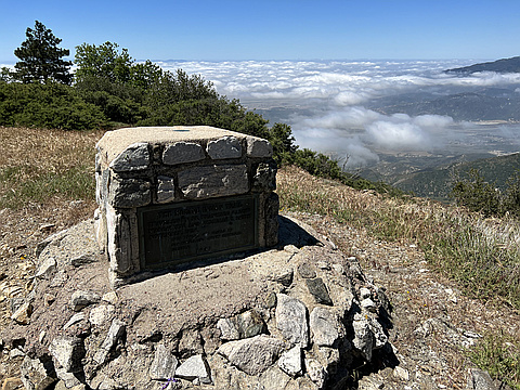
"Rode the mtb up from Cedarpines park. Lots of no trespassing signs and an expired road closure on the upper part of 2N43 made it bureaucratically interesting. 2N43 has a huge washout a third of the way up. Passable on bike or foot but not by car.
View from the summit was okay, I guess they included this for the monument/history and not for the aesthetic or geographical reasons." — edg • Aug 27, 2022
"Been planning this one for a while. Finally, the right day and conditions fell in place. It goes without saying that it is a long hike. 90% of the hiking is on Forest Road 2N49. If I had a 4WD vehicle, I could drive to the peaks, park, and walk the short summit trails. What is key in order to do it that way is the 4WD vehicle (which I don't possess). Fortunately, I had 2LD (leg drive) and an open day. I Managed to complete the day with no more than a 5 minute break. It took all day, but each listed peak got checked off." — MikeTeeples • May 30, 2022

"50 ft of prominence? That a stretch even for the HPS. Anyway, this was my last peak on a 5-peak bike-and-hike on Cleghorn Rd. From Monument, the plan was to ride down Sawpit Canyon back to the highway then to my car at the state park. But halfway down the mountain, my right of way ran into some very nasty no trespassing signs hand written in spray paint: "Get Out!" "Turn Around!" etc. Apparently somebody owns the middle portion of Forest Road 2N43. Rather than getting shot, my only option was to bike east up and around Jobs Peak which I was really not in the mood for. After the extra exercise, I spent a good while being quite lost in the maze of side streets up there with no map of the area and no cellular data. Eventually, I got just enough 4G to get some directions down a gnarly dirt road back to highway 138 and the car. Totals: 26 mi, 5000 ft." — klotito • Mar 31, 2018
Photos
Awards
Challenges
About peakery awards
Log successful summits on peakery to earn awards:
Peak Badges: Earn a special badge for each unique peak you summit. See all of your badges on your Badges page.

First Ascent Award: Only 1 available per peak. Goes to the first peakery member to log a successful summit of a peak. Snag this award and the peak will forever bear your name.

King of the Mountain Award: Only 1 available per peak. Summit a peak more times than any other member. Beware: this award can be lost!

Summit Steward: Summit a peak at least 5 times to become one of its Summit Stewards. As Steward of a peak, you’re encouraged to keep that peak’s info up-to-date on peakery and spread goodwill on your future climbs up the peak.