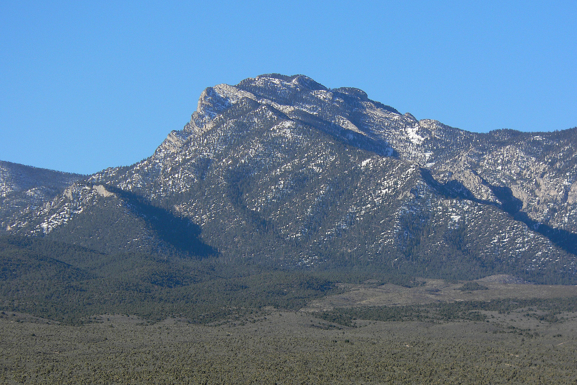
Region
Highlights
Routes
/-115.725708465576,36.3409333559004,11,0.00,0.00/320x240@2x?access_token=pk.eyJ1IjoicGVha2VyeSIsImEiOiJjampra3Z0bnAxeTVnM3FteHlybHY3b2p1In0.7a5dEa5-995VUv8ceHHNmw)
13 summits • 13.0 mi • 3,153 ft gain • 8 hr 54 min
4 summits • 17.1 mi • 2,945 ft gain • 8 hr 11 min
2 summits • 17.2 mi • 3,349 ft gain • 8 hr 28 min
1 summit • 11.0 mi • 2,857 ft gain • 8 hr 12 min
1 summit • 12.5 mi • 3,124 ft gain • 7 hr 30 min
1 summit • 6.6 mi • 3,675 ft gain • 8 hr 0 min
1 summit • 7.0 mi • 3,769 ft gain • 7 hr 6 min
1 summit • 7.6 mi • 3,940 ft gain • 7 hr 28 min
Latest summits

"Gunsmoke Peak was a last minute add to the original route we planned to McFarland and N. McFarland. We scrambled up a wash from the "standard" north route to McFarland that took us directly to Gunsmoke. Good, solid rock in the wash where we needed to get up cliff bands. Would do that route again. From Gunsmoke we took the ridge line traverse over to McFarland and then down the northern ridge line to North McFarland. The route was not difficult and definitely a good one to do again. " — Heartattackbruce • Sep 9, 2023

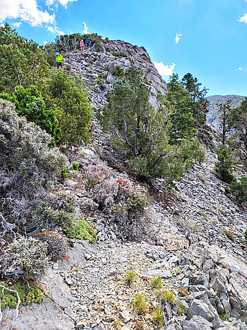
"This hike was very difficult for me actually. I would count this scree field as one of the more difficult scree fields I've done. Very unstable footing for 1000+ feet. Very steep. Not much scrambling needed as others have said. I did the entire ridge and all peaks from Bristlecone to McFarland, 4k elevation, 12 miles round trip, 8 hours, 6.5 hours moving time. " — solacesonder • May 26, 2023

"Followed gimpilators route to do these 3 peaks and somehow clocked me at 7 miles less when I recorded on alltrails . Nevertheless , very fun route , about 80% of it is on a nice trail only the last parts to each summit are off trail. McFarland is maybe a couple class 3 moves nothing crazy or exposed though . Lots of cairns too so route finding is never an issue. This is a super fun loop ! #10-12 of the Vegas 100 for me " — joshortman • Oct 6, 2022

"Oh McFarFarland. Didn't seem so far today. We put the turbo on and hit the peak in 3h 12m. 6h 5m car to car. Weather was absolutely gorgeous. Perfect temps, no wind. " — DudeAlmighty • Oct 5, 2022
"LVMC trip with 8 folks. I've taken the north canyon (L) route to McFarland at least 10x, and this was my 4th time coming down the N McF ridge. My main aim is to report on road conditions. My current preferred route is from the fenced ATV parking. The original HikingLasVegas road (reportedly) has a deep washout (which can be circumvented by taking a connector from Mud Springs Road.).
us95 , 36.5233996, -115.5475691
Fenced Parking, 36.4210964, -115.7307138
go-L-(SE), 36.3905688,-115.7184508
go-R-(South), 36.3844792, -115.7165411
go-R-(SW), 36.3950012, -115.718365
===========alternate===============================
MudSpringsRoad, 36.4558566, -115.6826604
mudSprConnector, 36.4185275, -115.7052338
McFarConnector, 36.4292791, -115.6879175" — hwstock • Sep 24, 2022

"oh McFarFarFARland. Haha! always a long, but rewarding hike. Beautiful day, some light cloud cover to keep us cool. I got a 2nd wind climbing back up the bonanza trail and was a little ahead of my group so I quickly tagged Divide peak." — DudeAlmighty • Aug 31, 2022

"10.3.2020~McFarland Peak/Bonanza peak Big CW loop. 17 miles (5 mountaineering/12 trail), 6,600’ gain, 8:45hrs. We didn’t get started til after 11am so we finished in the dark forest which was amazing. I underestimated the route distance by 6 miles so we were beyond exhausted and Jimmy was NOT happy with me. It was a Sufferfest of epic proportions. Early on, ‘‘twas a nightmare to fight our way through thick Scratchy brush that thrashed and sliced up our legs. I tweaked my back after a mile and had major spasms that immobilized me. It held us up for a half hour as we iced my back with my frozen bottle and massaged it with the hiking stick so I could move again.....It calmed down and we carried on. I was in pain the whole time but didn’t give up! Great day. Lots of wild horses, bones and switchbacks! Hot too...Oy! My husbands 1st McFarland Peak and my 4th.
https://youtu.be/iFw5mP0XgzM
" — paula.raimondi • Oct 3, 2020

"9.30.2020, McFarland Peak #3, Solo....8 miles, 3,500 gain round trip on foot in 4:54hrs, 3 miles round trip Mtn bike. This peak is the 4th highest in the Spring Mountains and considered by many to be the hardest Peak in the Range to climb. I have a stress fracture in one of my metatarsal so it was slow but steady. Luckily it isn’t too painful. (God forbid I rest it, tee hee) Beautiful day with bountiful solitude. Days are getting shorter. Farewell September. See you next year....
https://youtu.be/7M7d1QQGghQ" — paula.raimondi • Sep 30, 2020

"7.7.2020, McFarland Peak. Solo....This seldom visited peak is the 4th highest in the Spring Mountains and considered by many to be the hardest Peak, in the Range, to climb. 2nd time up, 1st time using the classic route up the Gully from the Bonanza trail. I have to tell you....doing it alone was creepy and there were a few cruxes with slanty, mild class 3 parts with exposure visuals that gave me pause but I was relentless and soldiered to the top with laser focus. My pace was a Dawdle but it is hard to face the wall of fear in a hurry. I Mtn biked to the Junction of the Bonanza trail because I was lazy and didn’t want the extra miles. I locked the bike to a tree and trekked on from there and coasted the bike down when I was done. 8.5 miles, 3,800’ gain on foot, 6 miles Mtn bike. It was a magical day. I was graced by wild horses, wildflowers, cool wind, the bliss of solitude in the forest and another successful project in the done pile. McFarland Peak is my new friend. He’s a giver....I may climb it 100 times, or at least 50....
https://youtu.be/dJkG7JXY9Ys
https://youtu.be/K_tvxWVgSIs
https://youtu.be/mPwFX3TBlp0
" — paula.raimondi • Jul 7, 2020

"We were supposed to take a long weekend to drive up to and climb Mount Shasta for Rainier training, but they had a stormy week and there was the threat of avalanches, so we stayed local. Started at the Upper Bristlecone trailhead and followed the Bristlecone Trail to the Bonanza Trail, which we took the base of the mountain. From there, it is a slog up a loose, rocky gully to the top. We came back the same way, for the most part. Erica and I made a quick stop at Divide Peak on the way back, since she hadn't been there before. We also took the 'No-name Trail' down, for a quicker, steeper descent." — Kevin • May 18, 2018
Photos
Awards
Challenges
About peakery awards
Log successful summits on peakery to earn awards:
Peak Badges: Earn a special badge for each unique peak you summit. See all of your badges on your Badges page.

First Ascent Award: Only 1 available per peak. Goes to the first peakery member to log a successful summit of a peak. Snag this award and the peak will forever bear your name.

King of the Mountain Award: Only 1 available per peak. Summit a peak more times than any other member. Beware: this award can be lost!

Summit Steward: Summit a peak at least 5 times to become one of its Summit Stewards. As Steward of a peak, you’re encouraged to keep that peak’s info up-to-date on peakery and spread goodwill on your future climbs up the peak.