Region
Most climbed route
Santa Barbara Campground to Truchas Lakes to Chimayosos Peak to Barbara Peak
29.5 mi • 6,065 ft gain
Highlights
Routes
/-105.59178829197,35.9759918776078,11,0.00,0.00/320x240@2x?access_token=pk.eyJ1IjoicGVha2VyeSIsImEiOiJjampra3Z0bnAxeTVnM3FteHlybHY3b2p1In0.7a5dEa5-995VUv8ceHHNmw)
2 summits • 29.5 mi • 6,065 ft gain • 81 hr 40 min
Latest summits

"Reaching Little Chimayosos Peak requires a long hike given its remote location. A popular route starts at the Santa Barbara campground/trailhead which is located north of the mountain. From the "free" hikers parking lot (elevation about 8850') to the summit of the peak was a one way hike of about 14 miles and an elevation gain of over 4000' thus requiring an overnight stay. One of the primary benefits of taking this route (trails 24 and 25) is multiple access points to water without leaving the trail. There's also a nice multi-site camping area with nearby water access, next to trail 25 after passing No Fish Lake. Getting to the trailhead: This trailhead is located in a remote area with no cell phone access. From the junction of NM-75 (High Road to Taos) and NM-73, follow NM-73 for 1.4 miles to Santa Barbara Road (small street sign not easy to see) on your left. It's 6.2 miles to the campground. There are no forest service signs pointing the way and the small street sign for Santa Barbara Road is easy to miss. Once you get near the campground you will pass by the "free" parking area followed by a fee parking area ($5 per day). If you are concerned about the contents of y..." — fredbrown585 • Sep 9, 2021

"Loop run beginning at the Santa Barbara camp ground, up the East fork of the Rio Santa Barbara then across the ridge and back down along the West fork of the Rio Santa Barbara." — Brian-Pilgrim • Jul 25, 2015
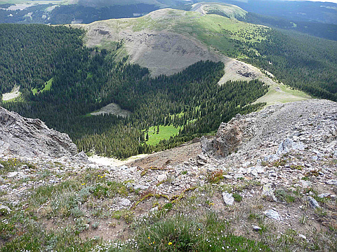
"Day 1: I have hiked Truchas Peak 5 times before but have never hiked the other 3 Truchas peaks. On Saturday morning, July 11, 2009 I left the house at 5 AM with my son Garret. I hiked with him to Truchas Peak when he was 12 and his brother Brandon was 10. He is now 29. We drove to Santa Barbara campground and began to hike about 8 AM. Our goal for the day was the Truchas Lakes. We hiked into the Pecos Wilderness and up the West Fork of the Santa Barbara. I have hiked out this way 3 times before but never hiked up. Most people do this hike in 2 days. It is 13 miles to the Truchas Lakes by the signs, but my GPS said it was 11 miles. We were starting at an elevation of 8800 feet and going to the ridge which is 12000 feet. It is a gorgeous canyon, one of my favorite in NM. The first half of the hike has an elevation gain of only 1000 feet and there are some beautiful meadows for a first night’s stay, but we pressed on. This is the 4th year straight that I have been doing these hikes with my son, and what a joy it is for me to do that with him. On past hikes we had 50 to 55 pound packs, but we wanted to go lighter so that we could press on further. We converted to what I call Ultralight..." — Phil-Robinson • Jul 13, 2009
Awards
Challenges
About peakery awards
Log successful summits on peakery to earn awards:
Peak Badges: Earn a special badge for each unique peak you summit. See all of your badges on your Badges page.

First Ascent Award: Only 1 available per peak. Goes to the first peakery member to log a successful summit of a peak. Snag this award and the peak will forever bear your name.

King of the Mountain Award: Only 1 available per peak. Summit a peak more times than any other member. Beware: this award can be lost!

Summit Steward: Summit a peak at least 5 times to become one of its Summit Stewards. As Steward of a peak, you’re encouraged to keep that peak’s info up-to-date on peakery and spread goodwill on your future climbs up the peak.