Region
Highlights
Routes
/-121.547506,47.417904,11,0.00,0.00/320x240@2x?access_token=pk.eyJ1IjoicGVha2VyeSIsImEiOiJjampra3Z0bnAxeTVnM3FteHlybHY3b2p1In0.7a5dEa5-995VUv8ceHHNmw)
21 summits • 8.5 mi • 3,133 ft gain • 5 hr 31 min
3 summits • 6.8 mi • 2,825 ft gain • 4 hr 55 min
2 summits • 9.7 mi • 3,875 ft gain • 8 hr 25 min
1 summit • 11.2 mi • 4,335 ft gain • 3 hr 31 min
1 summit • 13.1 mi • 4,757 ft gain • 7 hr 6 min
1 summit • 13.9 mi • 5,532 ft gain • 10 hr 26 min
1 summit • 26.0 mi • 6,688 ft gain • 8 hr 41 min
1 summit • 7.3 mi • 2,931 ft gain • 6 hr 5 min
1 summit • 8.8 mi • 3,296 ft gain • 6 hr 37 min
Latest summits

"A steep and cold climb on a perfect day to this sub peak. Took the Ira Springs Trail to the Bandera Mountain Trail, which was insanely steep at times, to the summit. Overall rating 7/10, absolutely worth the hike even if not going to the true summit" — MountainQuest • Oct 30, 2021

"Planned to hit Bandera Mountain Summit, 2nd time, and 4th for Little Bandara. Perfect blue skies - almost too perfect as the temps rose. Started at exit 42 - Tinkham vs. the Ira Springs trailhead, in part to avoid parking crowds and the dusty potholed road, plus the lower trail is a beautiful moss-covered trail with stumps of old grown tree harvested long ago, with beautiful stream flowing along the trail. There are no water sources once you pass the log bridge, and the true summit to Bandara is long and hot as it's exposed to the sun. Wildflowers along the steep boot path to Little Bandera are in full bloom, so take your time and enjoy the many colors. All lakes are melted out and the trail to Bandera Mountain summit is completely snow-free. There is a talus field of a couple of hundred yards marked with cairns to navigate once you get to the final stretch. The talus covered summit has a summit register, a small box with some papers, and other odd items. From the summit looking South Rainier looms larger than ever. There is a massive blow of talus below and it could be an interesting scramble adventure to explore and connect with the trail for Talpus Lake in the future. ..." — markhadland • Jul 25, 2020

"The trail was in great condition, better than my legs! This is a challenging but rewarding hike. The views were perfect with very prominent and clear shots of McClelland Butte, Mount Kent and Duke of Kent peaks at the beginning part of the hike and when the trail splits to Bandera vs. Mason Lake, Mount Rainier becomes the main attraction! The trail steepens considerably at this point and feels a lot more like Mailbox Peak. The beargrass is now out, along with pink heather, creating great photo opportunities. This is one of my favorite Hikes. The. Route to The real summit beyond Little Bandera requires some route finding. I was surprised that there was still a snow filed to cross on the backside of the ridge. There are options to hike along the I-90 side of the ridge which I did on the return or the backside which I did on the ascent. The summit offers wonderful views of Mason Lake, Mount Defiance, Webb Mountain, Mount Rainier, Mount Roosevelt, Kaleetan Peak, Chair Peak and Chimney Rock along with a number of less prominent peaks. Don’t forget to sign the summit register on top! There are not a lot of entries!!" — joeerickson • Jun 11, 2019

"Hiked to the summit of Little Bandera with Mark Hadland and then onto the summit of "Big" Bandera in blizzard conditions and low visibility. It was a big surprise to be hiking through snow finding our way to the summit with some challenging route finding conditions." — joeerickson • Jun 10, 2018

"Ira Springs TH to Little Bandera to Bandera. Pretty warm, 5 liters for the two of us was just right. Wouldn't have minded another liter.
Trail in good shape, though it got a bit harder to read after Little Bandera." — mathiasricken • Aug 27, 2017

"Great day for a quick training hike up a trail we would never consider doing on a weekend because of the crowds. There is not much to add about the trail, which is accurately described on the Bandera Mountain page and the numerous trail reports. It will be interesting to see how the trail holds up in the years ahead beyond the split to Mason Lake where the route heads pretty much straight up. The erosion is getting pretty bad before you finally get up to the ridge. After hitting the false summit we continued on towards the true summit for about 15 more minutes, but could see that it didn't look like the most enjoyable route (no trail and lots of brush to push through) to a point that is not even 100 feet higher than the false summit, and apparently without any superior views.
We ran into very few people (everyone else was going to or coming from Mason Lake), and there was a nice breeze that kept the bugs to a minimum. We would suggest this hike for a weekday afternoon/early evening. It's not the most exciting hike up, but it's a good workout the last mile or so, the views are nice for being so close to Seattle, and the travel time is minimal. The breakdown of our time:
2:00 ..." — BryHong8 • May 27, 2015

"I guess technically we hit Little Bandera a second time, when returning from the true Bandera summit :) But technically, I've also done this mountain a jillion times and not logged it..." — diana • May 28, 2012

"Headed up Ira Spring Trail under thick overcast, at about 3800 ft elevation I emerged above the cloud ceiling. Absolutely gorgeous everywhere I looked. On to Bandera Summit!" — Jeb • Sep 13, 2011
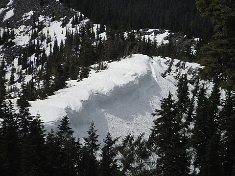
"Joel and I set off on the Ira Spring Trail around 10 am and despite the snow the parking lot was full. The trail hit snow after just a half mile and we chained up for the remainder. After the second switchback sent us westward the hillside opened up to a massive snowfield that was melting rapidly and exposing in some places the open rock field beneath. We carefully made our way across this to a bare section of the rocks where we turned and climbed directly up until we reached the plaque dedicated to Ira Spring. From here we proceeded east along the ridge line to summit, where the south face had melted away and meadows were pushing through. The rest of the ridge to Bandera Mountain Summit was completely covered in snow and so we opted stop here. After a quick lunch and some great pictures we headed back down as it was getting too cold not to be moving. Sliding most of the way down through the snow fields made our descent quick and enjoyable. A third of the way down we passed a hiker with a snowboard making his way up, making both of us a little jealous. Sounds like a great way down to me. " — Jeb • Jun 5, 2011

"Perfect bluebird day in the 70s. Hit snowline around 3700 ft and it was all snow from there. Postholed a bit on way up to ridge but then snow firmed up on way up to summit. Great views of the Snoqualmie Corridor, Mount Defiance, and beyond. Up on the summit, an aggressive bird almost snatched a Snickers out of my hand; be careful up there. Great glissading on the way back down; snow so soft no ice axe needed. Imagine this snow won't melt out for a LONG time." — scott • Jun 4, 2011
Awards
About peakery awards
Log successful summits on peakery to earn awards:
Peak Badges: Earn a special badge for each unique peak you summit. See all of your badges on your Badges page.

First Ascent Award: Only 1 available per peak. Goes to the first peakery member to log a successful summit of a peak. Snag this award and the peak will forever bear your name.

King of the Mountain Award: Only 1 available per peak. Summit a peak more times than any other member. Beware: this award can be lost!

Summit Steward: Summit a peak at least 5 times to become one of its Summit Stewards. As Steward of a peak, you’re encouraged to keep that peak’s info up-to-date on peakery and spread goodwill on your future climbs up the peak.