
Region
Most climbed route
Highlights
Routes
2 climbs • 8.5 mi • 1,943 ft gain • 3 hr 42 min
1 climb • 14.1 mi • 3,055 ft gain • 5 hr 17 min
1 climb • 6.9 mi • 1,610 ft gain • 2 hr 28 min
1 climb • 20.1 mi • 3,378 ft gain • 8 hr 7 min
1 climb • 9.0 mi • 2,214 ft gain • 6 hr 11 min
Latest climbs
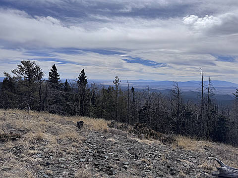
"I parked where the dirt road stopped being maintained. It ended up being quite a trek from there, but there were several sections of the road with deep holes and ruts that I wouldn’t trust my Subaru Outback to handle, so I’m glad I decided to walk it.
The hike to Glorieta Baldy was straightforward and mostly followed Glorieta Baldy Road (FR-375). From Glorieta Baldy, the route toward Thompson Peak was easy to follow until about 0.25 miles from the summit. At that point the trail became cluttered with a lot of fallen trees and branches. There are orange markers tied along the route, but this section does involve some light bushwhacking.
The photo was taken at the summit of Thompson Peak. Overall it was quite a long trek for views that weren’t particularly impressive." — collinrise • Mar 14, 2026
"I hiked up 375 to Glorieta Baldy last week, and couldn't find the trail to Thompson Peak from there. I had also discovered on that hike that despite having 4WD, I didn't have the clearance to get across the runoff channels. With that option out of the question and my desire to not hike up 375 again, it seemed there was no way to get up there without clocking 15 miles.
So I parked near the Apache Canyon Loop Trailhead, from where there is a good route to Sierra Pelada, too, and figured I would start the hike around Apache Creek. I brought my mountain bike thinking I would be able to fly the initial 3-4 miles to the main trail which were primarily downhill, then I could ditch the bike and end up having a short enough hike to Thompson Peak to return to the bike and get back. WAY TOO ambitious. I ended up ditching the bike only maybe 1.5 miles from the parking area after having to primarily walk it anyway (I am not built for mountain biking, it was just a gravity-based shortcut for me), including walking the bike up a few wrong turns. After ditching the bike I began the hike towards Glorieta Baldy. All day I had partly been hoping that from this angle the trail between Glorie..." — chrisjohnston • Jun 21, 2025
"I had been doing research for some time to find an access point to this peak, as it seemed like the parking and trailhead options were >15 miles out from the summit no matter what direction one looked. I tried the week prior to find the trailhead that appeared to be right in Glorieta, but it was fully private property and a summer camp. I finally got on the USFS website and they had detailed info about roads that were open to highway-legal vehicles.
I was able to get pretty deep into Santa Fe Nat'l Forest in a 4x4 on 375 via I-25 to 63A. The unpaved route I took to the start was actually relatively smooth being in a 4x4 with decent clearance. I was forced to stop and turn around in a narrow section where the channels in the dried earth were too deep for my standard-sized tires. I parked exactly where I started on the GPX track, there was a little crossroads with another route of some sort with some shade and protection from the wash.
I hiked to the top on 375 entirely, its pretty steep at times despite being a forest road. There was a trail on La Cueva Ridge pictured on the map, which I intended to use to ascend, but I was unable to find it from the east. The actual sum..." — chrisjohnston • Jun 14, 2025

"The hike today completes the final 2, of the 22 peaks on the Santa Fe Classic’s list on peakery.com . For the most part I am only interested in peaks in New Mexico that are taller than 10,800, but I wanted to complete the list.
I left my home, June 19, 2017, with my friend Jim at 6:45 AM. On Interstate 25 we took exit 299 in the town of Glorieta, headed east on highway 50, then north on CR 63A. CR63A turns into FR 375. It is about 12 miles from the start of CR 63A to Glorieta Baldy. We wanted to get more of a hike so we did not drive all the way to Baldy, rather stopped 2 miles, as the crow flies, east of the peak. Other trip reports said the road was very poor towards the end, but today the road grader was making a final sweep of the road. We passed him hiking. So as of this date, the dirt road is very good all the way to Baldy, but I can see that changing rapidly with monsoon rains. We started hiking at 8:45 at an elevation of 8650 feet. The hike started off cool and clear but quickly warmed up. It was a rich beautiful green forested hike with aspen, blue spruce, white fur, and wildflowers. We hiked up the road and I could see the top on my GPS so I shimmied up a hill. Jim wen..." — Phil-Robinson • Jun 19, 2017
Photos
Awards


Challenges
About peakery awards
Log climbs on peakery to earn awards:

Peak Badges: Earn a special badge for each unique peak you summit. See all of your badges on your Badges page.

First Ascent Award: Only 1 available per peak. Goes to the first peakery member to log a successful summit of a peak. Snag this award and the peak will forever bear your name.

King of the Mountain Award: Only 1 available per peak. Summit a peak more times than any other member. Beware: this award can be lost!

Summit Steward: Summit a peak at least 5 times to become one of its Summit Stewards. As Steward of a peak, you’re encouraged to keep that peak’s info up-to-date on peakery and spread goodwill on your future climbs up the peak.