Region
Highlights
Routes
/-115.485490647051,35.9952864220578,11,0.00,0.00/320x240@2x?access_token=pk.eyJ1IjoicGVha2VyeSIsImEiOiJjampra3Z0bnAxeTVnM3FteHlybHY3b2p1In0.7a5dEa5-995VUv8ceHHNmw)
1 summit • 5.2 mi • 276 ft gain • 2 hr 56 min
1 summit • 5.4 mi • 2,858 ft gain • 4 hr 58 min
1 summit • 6.1 mi • 666 ft gain • 3 hr 25 min
1 summit • 7.4 mi • 2,583 ft gain • 5 hr 28 min
1 summit • 5.3 mi • 2,914 ft gain • 5 hr 4 min
Latest summits
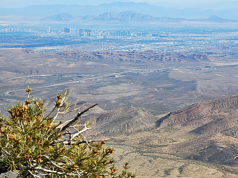
"We decided to check an alternate trail on the way down. The trail was easy to follow, went by caves and great scenery, but is little-used; we cut down from that WNW-trending trail to the road. The Clark County records show this is still BSA land, and I don't recommend this way because of the potential trespassing (even though there are no signs, and the BSA have erected signs and built trails on USFS and BLM land). The only totally non-trespass way to reach North Potosi, is on the ridge to the ENE of the summit; and that route requires a legal (but gymnastic) drop through a near-highway fence (see my other TRs)." — hwstock • Nov 5, 2023
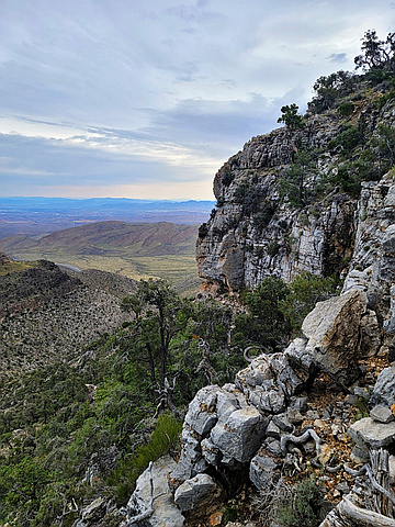
"This a good shoulder-season trip, as one starts in the shade before 8AM. I dont post here much, except to say what not to do! The way I took up "The Fortress" (named by BSA long ago, here called "Cottonwood Overlook"), Meditation Point, North Potosi (here called "Buddha's Rest") started with some totally unnecessary breaking through a cliff band. I explored some shelters (shallow caves) that I had seen for years. It rained about half the day, just light sprinkles, but the weather put a slight damper on my explorations." — hwstock • Sep 10, 2023
"The southern route shown here is the only LEGAL access I know to North Potosi ("Buddha's Rest"). Meditation Point is on private land. Much has changed since I went in 2018; there a fence along rte 160, designed to keep people from dumping. There are legal points to drop through that fence; the catch is that you have to drop and climb out over a 6' concrete wall." — hwstock • Sep 28, 2021
Awards
About peakery awards
Log successful summits on peakery to earn awards:
Peak Badges: Earn a special badge for each unique peak you summit. See all of your badges on your Badges page.

First Ascent Award: Only 1 available per peak. Goes to the first peakery member to log a successful summit of a peak. Snag this award and the peak will forever bear your name.

King of the Mountain Award: Only 1 available per peak. Summit a peak more times than any other member. Beware: this award can be lost!

Summit Steward: Summit a peak at least 5 times to become one of its Summit Stewards. As Steward of a peak, you’re encouraged to keep that peak’s info up-to-date on peakery and spread goodwill on your future climbs up the peak.