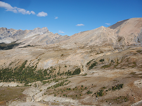
An additional collection of Canadian Rockies scrambling peaks from Andrew Nugara's book "More Scrambles in the Canadian Rockies" http://www.rmbooks.com/book_details.php?isbn_upc=9781771600163. Features peaks in the Kananaskis and north. Also see the companion challenge More Canadian Rockies Scrambles South for peaks in Waterton, The Castle, and Crowsnest areas.
Highest peak
Wind Mountain
10,344 ft / 3,153 m
Most prominent peak
Mount Lougheed
1,640 ft / 500 m prom
Most summited peak
Wasootch Peak
106 summits
Most difficult peak
Mount Fortune
Class 1
Difficulty breakdown
Class 1/2 6 peaks
Class 3/4 4 peaks
Highlights
Latest summits
"After being sick for two and a half weeks, I really wanted to get out. It was a perfect day, but I was definitely worn out still. Shannon hadn't done this one, so it worked out. This is an area will definitely have to go back to! Quartzite and Ramp Peak looked cool too, so maybe I'll go back for those sometime too." — leigh-annewebster • Sep 9, 2023

"After attempting this one twice before the time had come to get it done. I started out hiking at 6:43am, pushed until I got to the summit. I had some minor routefinding to do but it was not bad by any means. There was some handy flagging that definitely helped me out. I reached the summit, took a few pics and started to head down as there already was dull distant thunder. About 10 mins in to the descent I was caught in a full on thunderstorm directly overhead. The mountain turned white. I waited a few mins but ultimately had to get down. Once off the summit block things got better but the rain went on and I was soaked when I got back to the car." — BertB • Aug 6, 2023
"We modified the route by going up the SW Ridge of Wasootch. We also added an additional peak (Peakery) by doing an out-and-back from Kananaskis Peak to one of her outliers. To start, we parked at Evan-Thomas Creek Day Use area because this is where we would finish. We then biked mostly down hill for about 5km to the unmarked Trailhead for the SW ridge to Wasootch Peaks.
On decent from Wasootch North, we dipped into the bowl on the east side. Chelsea and I each ended up on separate routes (one high, one low), both worked. This helped avoid additional elevation gain if we were to back track all the way to Wasootch South.
Scrambling along the ridge was a lot of fun. As mentioned in many other trip reports, you have the option to take scree bypasses around many sections. We didn’t take any of the bypasses and found the scrambling to be quite enjoyable (class 2/3 in my opinion). The rock was solid anytime we felt real exposure. So my recommendation would be to favour the ridge when presented with an option. If you don’t like exposure, or your trying to minimize trip duration, take the bypasses.
It felt like 75% of the traverse was straightforward ridge walking with eas..." — ivo • Jul 29, 2023