Highest peak
Lantau Peak
3,064 ft / 934 m
Most prominent peak
Lantau Peak
3,064 ft / 933 m prom
Most summited peak
Lantau Peak
22 summits
Most difficult peak
Dog Teeth Range (Middle)
Class 1
Difficulty breakdown
Class 1/2 1 peak
Highlights
Latest summits

"Start (and intended finish) Tung Chung MTR exit D
Actual finish Pak Kung Au bus stop on Tung Chung Road (for regular #11 and 3M buses to Tung Chung MTR or Mui Wo Ferry) http://www.i-busnet.com/english/info/lantau/list.htm
Enticed (duped!) by a dry bright weather forecast I’d planned a hefty clockwise horseshoe circuit of Sunset Peak including sidetracks to all the subsidiary peaks. Woke up in the morning to extensive cloud and drizzle, but not to worry, the revised forecast* was for a little rain clearing through by midday replaced by fine weather, so off I went up HKs 3rd highest peak. Initially all went to plan up Por Kai Shan and Pok To Yan in warm dry conditions. The HK haze was burning off and a cap of benign cloud on Lantau’s highest peaks seemed to be breaking up:) In the event however the expected afternoon improvement didn’t materialise, rather everything deteriorated steadily so that thickening clag, driving rain and a strong gusty wind became the order of the day. The trails became slippy and photography difficult so I have few pictures from later. When my GPS device battery run out on Sunset Peak I’d had enough; I binned my planned descent route over minor peaks S..." — davidb • Feb 11, 2020

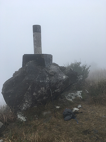
"Pok To Yan is a pleasantly defined ridge, quite narrow at one point, with three summits and is traversed by a narrow trail
The middle peak is the highest and has the shattered stump of an old trig point
The eastern peak is home to a newer, less damaged, trig point
The western peak is vegetated with no summit feature
Start (and intended finish) Tung Chung MTR exit D
Actual finish Pak Kung Au bus stop on Tung Chung Road (for regular #11 and 3M buses to Tung Chung MTR or Mui Wo Ferry) http://www.i-busnet.com/english/info/lantau/list.htm
Enticed (duped!) by a dry bright weather forecast I’d planned a hefty clockwise horseshoe circuit of Sunset Peak including sidetracks to all the subsidiary peaks. Woke up in the morning to extensive cloud and drizzle, but not to worry, the revised forecast* was for a little rain clearing through by midday replaced by fine weather, so off I went up HKs 3rd highest peak. Initially all went to plan up Por Kai Shan and Pok To Yan in warm dry conditions. The HK haze was burning off and a cap of benign cloud on Lantau’s highest peaks seemed to be breaking up:) In the event however the expected afternoon improvement didn’t materialise, rather eve..." — davidb • Feb 11, 2020
"Start (and intended finish) Tung Chung MTR exit D
Actual finish Pak Kung Au bus stop on Tung Chung Road (for regular #11 and 3M buses to Tung Chung MTR or Mui Wo Ferry) http://www.i-busnet.com/english/info/lantau/list.htm
Enticed (duped!) by a dry bright weather forecast I’d planned a hefty clockwise horseshoe circuit of Sunset Peak including sidetracks to all the subsidiary peaks. Woke up in the morning to extensive cloud and drizzle, but not to worry, the revised forecast* was for a little rain clearing through by midday replaced by fine weather, so off I went up HKs 3rd highest peak. Initially all went to plan up Por Kai Shan and Pok To Yan in warm dry conditions. The HK haze was burning off and a cap of benign cloud on Lantau’s highest peaks seemed to be breaking up:) In the event however the expected afternoon improvement didn’t materialise, rather everything deteriorated steadily so that thickening clag, driving rain and a strong gusty wind became the order of the day. The trails became slippy and photography difficult so I have few pictures from later. When my GPS device battery run out shortly after Sunset Peak I’d had enough; I binned my planned descent route over mi..." — davidb • Feb 11, 2020

"Start (and intended finish) Tung Chung MTR exit D
Actual finish Pak Kung Au bus stop on Tung Chung Road (for regular #11 and 3M buses to Tung Chung MTR or Mui Wo Ferry) http://www.i-busnet.com/english/info/lantau/list.htm
Enticed (duped!) by a dry bright weather forecast I’d planned a hefty clockwise horseshoe circuit of Sunset Peak including sidetracks to all the subsidiary peaks. Woke up in the morning to extensive cloud and drizzle, but not to worry, the revised forecast* was for a little rain clearing through by midday replaced by fine weather, so off I went up HKs 3rd highest peak. Initially all went to plan up Por Kai Shan and Pok To Yan in warm dry conditions. The HK haze was burning off and a cap of benign cloud on Lantau’s highest peaks seemed to be breaking up:) In the event however the expected afternoon improvement didn’t materialise, rather everything deteriorated steadily so that thickening clag, driving rain and a strong gusty wind became the order of the day. The trails became slippy and photography difficult so I have few pictures from later. When my GPS device battery ran out on Sunset Peak I’d had enough; I binned my planned descent route over minor peaks S..." — davidb • Feb 11, 2020
"Start (and intended finish) Tung Chung MTR exit D
Actual finish Pak Kung Au bus stop on Tung Chung Road (for regular #11 and 3M buses to Tung Chung MTR or Mui Wo Ferry) http://www.i-busnet.com/english/info/lantau/list.htm
Enticed (duped!) by a dry bright weather forecast I’d planned a hefty clockwise horseshoe circuit of Sunset Peak including sidetracks to all subsidiary peaks. Woke up in the morning to extensive cloud and drizzle, but not to worry, the revised forecast* was for a little rain clearing through by midday replaced by fine weather, so off I went up HKs 3rd highest peak. Initially all went to plan up Por Kai Shan and Pok To Yan in warm dry conditions. The HK haze was burning off and a cap of benign cloud on Lantau’s highest peaks seemed to be breaking up:) In the event however the expected afternoon improvement didn’t arrive, instead everything then deteriorated steadily and thickening clag, driving rain with strong gusty winds became the order of the day. The trails became slippy and photography difficult so I have few pictures from later. When my GPS device battery run out shortly after Sunset Peak I’d had enough; I binned my planned descent route over minor pea..." — davidb • Feb 11, 2020