no info yet
no info yet
no info yet
no info yet
Cat Mountain + Thomas Mountain
December 23rd, 2018
Cat Mountain
9:30a We started at 8am this morning, I was hungry and tired when I woke up and did most of this hike with a headache. The plan is to do this as well as Thomas Mountain today. This will be my longest hike to date at over 6 miles. Francis and Eli walk extremely fast up the mountain and it is hard to keep up with them. I am also way to nice to ask them to slow down. This came back to bite me in the butt since just a few seconds ago I stopped sat down on a rock and began feeling like I was gonna puke. I tried stopping myself but when Francis and Eli asked if I was having a heart attack I had to talk and tell them that I felt like I was gonna puke. Sure enough the talking made me throw up the only two things I had in my stomach. A banana and water.
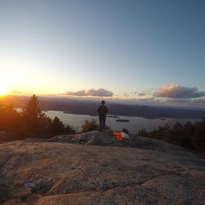
9:41a We just made it to the top. Francis and Eli are off taking pictures and pointing out mountains and I am still recovering. We took a non-supported train up so we actually ended up walking up the side of a cliff to get here. It was a nice view but at the same time, a very hard climb. The top is amazing and I can see the Pinnacle from here.
10:26a On the way up Eli and Francis were talking about a geocache that was located around the top of the mountain that looked like an ammo box. They opened their phones and looked up the location of it and we began searching for it. Eventually we gave up and began to head out when Francis exclaimed “Well it has to be off the ground” as he said that I looked up and saw it hanging in a tree. It was pretty cool and when we looked inside I found a chip with a code that can be tracked on Geocaching.com. So I took that and I left a new pen so people could write their name since the one inside of it had run out of ink.
Thomas Mountain
10:43a After finding the geocache we headed down Cat Mountain towards Thomas Mountain. They keep talking about all the fun they have had hiking and I feel bad that I can’t contribute since I just started. I can’t wait to be able to share stories and experiences like theirs.
11:53a We just reached the top of Thomas Mountain. They don’t really stop to wait for me to write things down so I am just jotting quick things down whenever I can. This view is a lot more narrow than Cat Mountain and is definitely at a lower elevation. According to Francis we walked over two small hills to get here, which I believe. Just before we reached the top there was a cliff that seemed to go straight up to the summit of the mountain. It took my breath away when I saw it because not only did it go straight up but it didn’t seem to have any short incline up. When we reached the very bottom of it Eli pointed out that the trail wasn’t a rock-climb up the mountain but a steep walk up the side of it. They ran up the mountain and I made it about half way up before I had to stop to catch my breath. I made it up about a minute after they did but it was worth taking a little break because my legs were quite tired at that point.
12:20p We just met a family with kids who had made it about a mile in towards Thomas without any microspikes or shoes. Quite concerned Francis recommended they visit the pond that was nearby instead of visiting the peak. Great hike but a long hike. My legs will be sore tomorrow for sure!
None
point-to-point/traverseroutefinding, bushwhacking, blowdowns
crampons, trekking poles, mountaineering boots
Other peaks climbed on this trip
