
Region
Highlights
Routes
/-117.47763668042967,34.35969111361531,11,0.00,0.00/320x240@2x?access_token=pk.eyJ1IjoicGVha2VyeSIsImEiOiJjampra3Z0bnAxeTVnM3FteHlybHY3b2p1In0.7a5dEa5-995VUv8ceHHNmw)
1 summit • 6.8 mi • 689 ft gain • 2 hr 23 min
Latest summits
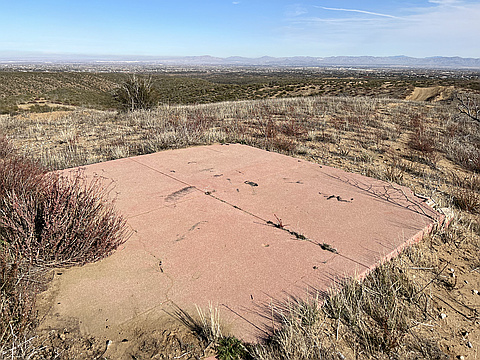
"Where Baldy Mesa Road turns to dirt at Mesquite Street, I parked there to begin the hike. Technically, I could've driven 2 Miles on the dirt road to reach another place to possibly park, but this worked out fine (I was there to hike anyway). The road turns into more of an offroaders dream after two Miles, as evidenced by the offroad vehicle's I encountered there. A bump sits at the edge of the rim overlooking Cajon Pass. This is the summit of Baldy Mesa. A foundation is all that remains on top. Great views make this high desert trek worthwhile. " — MikeTeeples • Dec 3, 2022

"Parked at the intersection of Baldy Mesa Rd & Mesquite Street. This is the point where Baldy Mesa Rd turns to dirt. My main motivation for parking there was to not get my car all dusty from the dirt road (and to not give my 7 year old daughter the ammunition she needs to write “Taylor Swift” in the dust on the side of my car when I get home). Instead, I traded mileage for a dust free car. For the first two miles, the dirt road was flat, hard packed, and a very smooth looking ride. I was convinced that I could have drove a golf cart on that road with no issues, meanwhile, I was walking on it. At about 2 miles, there is a construction site. After that, Baldy Mesa Road becomes a rugged forest road (3N24). Dirt bikers love this part of the road, and they often kept me company as I hiked. The first significant bump in sight is Baldy Mesa. The forest road goes along the edge of the cliffs that overlook Cajon Pass and Interstate 15. A vehicle fence prevents off road vehicles from driving to the summit. I stepped over it and walked the few easy feet to the high point. Other Peakery summits along the cliffs that I haven’t visited yet are also in view from the top and are connected ..." — MikeTeeples • Feb 1, 2020
Photos
Awards
About peakery awards
Log successful summits on peakery to earn awards:
Peak Badges: Earn a special badge for each unique peak you summit. See all of your badges on your Badges page.

First Ascent Award: Only 1 available per peak. Goes to the first peakery member to log a successful summit of a peak. Snag this award and the peak will forever bear your name.

King of the Mountain Award: Only 1 available per peak. Summit a peak more times than any other member. Beware: this award can be lost!

Summit Steward: Summit a peak at least 5 times to become one of its Summit Stewards. As Steward of a peak, you’re encouraged to keep that peak’s info up-to-date on peakery and spread goodwill on your future climbs up the peak.